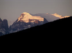
Photo: Looking south to Mount Quincy from the Ranger Hill Viewpoint on the Icefields Parkway
Mount Quincy
- 3150 m (10,335ft)
- First Ascent
- Naming History
Located in the Chaba River Valley south of the junction of Chaba River and Upper Athabasca River
Province: Alberta
Park: Jasper
Headwater: Athabasca
Visible from Highway: 93N
Ascent Party: Alfred Ostheimer
Ascent Guide: Hans Fuhrer, J. Weber
Named by: Arthur Coleman
Named for: Coleman, Quincy (Lucius Quincy Coleman was Arthur Coleman''s brother. He lived in Morley and was Arthur''s outfitter on Arthur Coleman''s 1892 and 1893 exploratory trips to the headwaters of the Athabasca.)
A large "massif" of extremely rugged terrain featuring steep cliffs, glaciers, and a spectacular tower lies between the Athabasca River to the east and the Chaba River Valley to the west. Arthur Coleman was a Professor of Geology at the University of Toronto who travelled widely in the northern Rockies beginning in 1884. During two of Coleman's major trips, his outfitter was his brother, Lucius Quincy Coleman who ranched in the Morley area of the Bow Valley. Arthur Coleman''s 1892 and 1893 exploratory trips began at Quincy''s Ranch near Morley. Using Quincy''s knowledge of area as well as native guides hired by Quincy, they travelled to the Saskatchewan via the foothills, Red Deer and Clearwater Valley and Whiterabbit Pass. Mount Quincy was named by Professor Coleman in 1892, perhaps to honour their mother''s family name but more likely to honour his brother. In his book, "The Canadian Rockies, Old Trails and New," Professor Coleman praises him highly for his ability in packing, tracking, and cooking and for his pleasant disposition. One of Quincy Coleman''s neighbours at Morley referred to him as, "a man of sterling character and a gentleman in every way." During his 1892 visit to the Rockies, Arthur Coleman left his packhorses and "tramped" up the Chaba River in search of Mount Brown and Mount Hooker. Fortress Mountain, as we named it, proved a harder proposition than we expected, and at 7,700 feet we halted at the foot of a vertical wall, with the valley and its creeks and rivers spread out more than three thousand feet below, and a grand array of mountains near its head a few miles to the south, the finest of which we afterwards called Mount Quincy." In 1901, at the suggestion of Jean Habel, the high point on the eastern edge was named Blackfriars Peak. The mountain reminded Dr. Habel of a peak in Europe with a similar name. Unclimbed until 1953, the first ascent of Blackfriars Peak was led by Walter Perren who in 1950 had become one of the last two alpine guides brought to Canada from Switzerland by the Canadian Pacific Railway. Although sixty metres lower than Blackfriars Peak, Mount Quincy features a beautiful glacier on its broad summit and a spectacular tower stands to its left when it is viewed from Highway #93. Alfred Ostheimer completed the first ascent of Mount Quincy, guided by Hans Fuhrer. Of the mountain, Ostheimer wrote, "Quincy''s summit was most picturesque. It was a joy to see the clean snow of spring still lingering upon the broad plateau crest; its purity -as it curled, exceptionally perfect, into wispy cornices wrapped in pall like fog -rivaled the "lilies of the field". Only on Mount Temple, near Lake Louise, have I seen another such superb wave of snow."
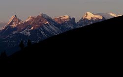
Photo: Looking south to Blackfriars Mountain (left) and Mount Quincy from the Icefields Parkway at the Ranger Hill Viewpoint
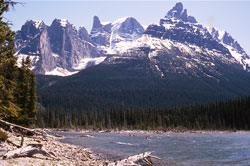
Looking southeast to un-named towers along the northwest side of Mount Quincy from Fortress Lake (courtesy Don Beers)
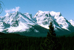
Looking south to Mount Quincy from Sunwapta Bluff (courtesy Don Beers)

Looking south to Mount Quincy from just north of the Sunwapta Falls Junction on the Icefields Parkway