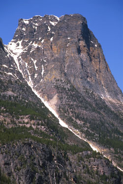
Photo: Looking to Fortress Mountain from the Chaba River Ford (courtesy Don Beers)
Fortress Mountain
- 3020 m (9,909ft)
- First Ascent
- Naming History
Located on the continental divide north of east end of Fortress Lake; north buttress of Fortress Pass
Province: Alberta/BC
Park: Jasper/Hamber
Headwater: Athabasca/Columbia
Major Valley: Athabasca
Ascent Party: R.L. Barrett (alone)
Named by: Arthur Coleman
Named for: The mountain resembles a fortress.
This mountain should not be confused with "The Fortress" of the Kananaskis Valley. The "Fortress Mountain Ski Resort" is located near "The Fortress." Arthur Coleman and party were the first to visit Fortress Lake that was named after the mountain. During his 1892 visit to the Rockies, Arthur Coleman left his packhorses and "tramped" up the Chaba River in search of the elusive Mount Brown and Mount Hooker that he had been led to believe were over 16,000 feet in elevation. Following the third night out, "The morning was brilliant and we left our bundles under the tree to climb a few thousand feet for an outlook. Fortress Mountain, as we named it, proved a harder proposition than we expected, and at 7,700 feet we halted at the foot of a vertical wall, with the valley and its creeks and rivers spread out more than three thousand feet below, and a grand array of mountains near its head a few miles to the south, the finest of which we afterwards called Mount Quincy." They gave up their original plan of climbing the mountain and, "Rounding the corner of the great buttress, whose foot we followed, suddenly there opened out below us the most marvellous lake imaginable. We were above its east end, and could see it stretching eight or ten miles to the west in a valley completely surrounded by heavy forest, sloping up to purplish cliffs and mountain-tops." Four years laterWalter Wilcox and Robert Barrett, "...set out to climb the peak north of the lake (Fortress Mountain) in order to discover the location of the highest mountains. We had a long and tiresome walk, through a heavy forest, and discovered a very old trail, so much blocked, however, by fallen trees as to be almost useless. After reaching a point about forty-five hundred feet above the valley, the weather became threatening, and I set up by camera at once and took a set of views around the horizon. The clouds formed constantly a few yards above by head, but I got the distant mountains, though the smoke and gloom made the results very poor. Barrett continued up the mountain, though the climb involved some rather perilous work among rotten limestone cliffs. He reached the summit, which is about ninety-six hundred feet high, where the clouds shut out everything from view." Wilcox likely saw Mount Clemenceau from here, writing: "The clouds opened a moment and disclosed what appeared to be by far the highest and finest peak that I had seen on the entire journey, ten miles to the south-west. It was a wedge-shaped peak, rising from a very long and precipitous wall of rock, which seemed to be over ten thousand feet high." [See Arthur Coleman biography;Walter Wilcox biography] [Additional Information: "The Canadian Rockies -New and Old Trails" by Arthur Coleman] [Additional Information: "The Rockies of Canada" byWalter Wilcox]
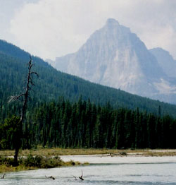
Photo: Looking west from the upper Athabasca River to Fortress Mountain (courtesy Aaron Osicki)
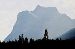
Photo: Looking southwest from The Crossing Campground (Athabasca & Chaba River junction) to Fortress Mountain (courtesy Aaron Osicki)