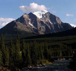
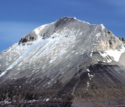
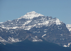
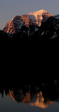
Photo: Looking south-southwest down the Pipestone River to Mount Temple from the Trans-Canada Highway
Mount Temple
- 3543 m (11,625ft)
- First Ascent
- Naming History
- Hiking and Trails
Located in the Bow River Valley between Paradise Creek and Moraine Creek; north of Moraine Lake; east buttress of Sentinel Pass
Province: Alberta
Park: Banff
Headwater: Bow
Major Valley: Bow
Visible from Highway: 1, 93N
Ascent Party: Samuel E.S. Allen, L.F. Frissel, Walter Wilcox
Named by: George Dawson
Named for: Temple, Sir Richard (Sir Temple visited the Rockies in 1884 as leader of the British Association Excursion Party.)
Journal Reference: App 7-281; CAJ 22-14
Clearly the most massive and the highest of the mountains of the Lake Louise area, Mount Temple is the first of the high peaks near the Continental Divide which one sees driving west along the Trans-Canada Highway. The view of the mountain from the vicinity of Castle Junction was described by Samuel Allen when he read an account of his first ascent of the mountain to the Appalachian Mountain Club in Boston on March 12, 1895. "One who travels west from Banff up the valley of the Bow will see in front of him, shortly after leaving Cascade Siding, a tall helmet-shaped peak rising in a series of inaccessible cliffs to a snow tipped summit. But it is not until Laggan is reached, and the western face of the peak is seen -now to the southeast -that its height or beauty is adequately realized, although from all points it dominates the landscape." Rising directly from the Bow Valley, the mountain offers three quite different views to the traveler, each of which features huge, steep cliffs. The view from Castle Junction makes clear the fact that this is a mountain different in height and character from those to the east. Looming 719 metres above Panorama Ridge, Mount Temple rises to an elevation of 3543 metres, its rock appearing darker and more purplish than the nearer ridge and its upper cliffs always highlighted by snow. From the Moraine Creek Bridge on the Trans-Canada Highway, the mountain seems very close. This is the narrowest that it appears and is a most impressive viewpoint even though the summit cannot be seen. Mount Temple is composed of quartzite and limestone that is early Cambrian in age, the formations being about 550 million years old. The view from Lake Louise is the classic one of Mount Temple and, again quoting from Wilcox's speech of March 12, 1895, "From a base fifteen hundred feet higher than Laggan, this western face rises in one unbroken wall of nearly four thousand feet. A plateau above the latter is occupied by a magnificent area of glacier and neve, sweeping down in curving folds from the summit to the top of the wall, while the overhanging seracs above, and the fine powder on the scattered ledges below tell of many a thundering avalanche of ice. This is Mount Temple." In 1894, Walter Wilcox, Samuel Allen, and L.F. Frissel made the first ascent of Mount Temple utilizing the southwest ridge. Despite the mountains inaccessible appearance from the various viewpoints in the Bow Valley, this so-called "Tourist Route" is of such difficulty that Ken Jones, the first Canadian born alpine guide, claimed that it is possible to "lead a milk cow to the top." Ken was of course joking, but technically it is an easy climb. However there are risks involved both from falling rock and, if the route is lost, steep cliffs and avalanches. In 1955 seven young people from the United States were killed on this route in Canada's most costly mountaineering accident. A group of eleven were climbing up a huge bowl on the southwest slopes of the mountain on a very warm July 14th. Ten of the boys were swept 200 metres down a snowfield and though a bottleneck before the snow stopped and set up like concrete. The cliffs of the north face of Mount Temple were not climbed until the 1960's. When viewed from the north and north-northwest (along Highway #93) a striking, steeply-dipping line of snow is seen connecting with the east ridge of Mount Temple about halfway up the mountain. This snow-highlighting is not related to the bedding planes but is formed from snow gathering in what is known as the Aemmer Couloir. Guide Rudolph Aemmer led Val Fynn up this route in 1918 in what Chic Scott describes as, "a serious attempt on this ridge from Paradise Valley." The pair reached the base of what is known as the "Black Towers" at the top of the couloir. Although there has been considerable confusion regarding the history of the naming of this spectacular mountain, including speculation that it was once referred to as Mount Lefroy, there is no firm evidence of a name for it until the arrival of George Dawson in the early 1880’s. He officially named the peak in honour of Sir Richard Temple, an economist who was the leader of a "British Association" field trip to the Canadian Rockies in 1884. Primarily interested in India, this was Sir Richard's only visit to Canada. George Dawson was working in the area during 1884 but it is not known whether the two met there. Perhaps they did and somehow Sir Richard made an impression on Dawson who then chose to name one of the most spectacular peaks in the area in his honour. Legendary alpine guide, Edward Feuz jr climbed Mount Temple in 1965 at the age of 81. [Gest]
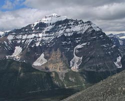
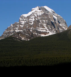
Looking west to Mount Temple from the Bow Valley Parkway
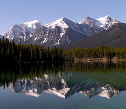
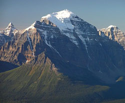
Looking south across Herbert Lake to (l-r) Mount Temple, Fairview Mountain, Haddo Peak, and Mount Aberdeen from the Icefields Parkway
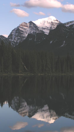
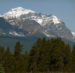
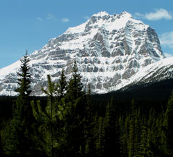
Looking south to Mount Temple from Herbert Lake on the Icefields Parkway
Looking south to the north face of Mount Temple from Sheol Mountain (courtesy Sonny Bou)
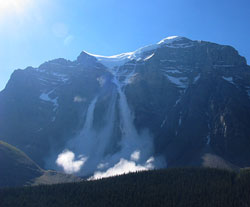
Avalanche on the north face of Mount Temple (courtesy Sonny Bou)
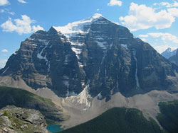
Looking south-southwest to Mount Temple (Mount Allen beyond to left; Pinnacle Mountain beyond to right) from Pika Peak (courtesy Vern De Wit)
Looking northeast to Mount Temple from Eiffel Peak (courtesy Gerry Hopkins)
Looking northeast to the summit of Mount Temple from Eiffel Peak (courtesy Gerry Hopkins)
Looking northwest to Mount Temple from Panorama Ridge (courtesy Sonny Bou)
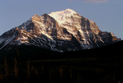
Looking northwest to Mount Temple
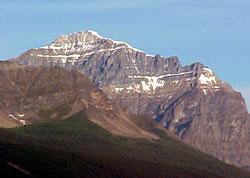
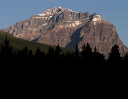
Photo: Looking northwest to Mount Temple from the Bow Valley Parkway, 2.5 km west of Castle Junction
Looking west-northwest to Mount Temple from Mount Ishbel (courtesy Sonny Bou)
Looking southwest to Mount Temple from the Bow Valley Parkway
Looking west to Mount Temple from the Bow Valley Parkway
Looking south-southwest to Mount Temple from the Bow Valley Parkway near Lake Louise Village
Looking south to Mount Temple from Herbert Lake on the Icefields Parkway
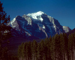
Photo: Looking south to Mount Temple from the Bow Valley near Lake Louise Village (courtesy Dr. John D. Birrell)
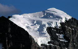
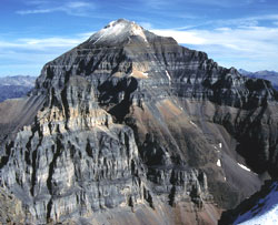
Looking south-southwest to the glacier draped summit of Mount Temple
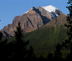
Looking south-southwest to Mount Temple from the Bow Valley Parkway