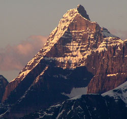
Photo: Looking south to Blackfriars Peak from the Ranger Hill Viewpoint from the Icefields Parkway
Blackfriars Peak
- 3210 m (10,532ft)
- First Ascent
- Naming History
52.3261N -117.618W
Located in the Upper Athabasca River Valley north of Quincy Creek
Province: Alberta
Park: Jasper
Headwater: Athabasca
Major Valley: Athabasca
Visible from Highway: 93N
Located in the Upper Athabasca River Valley north of Quincy Creek
Province: Alberta
Park: Jasper
Headwater: Athabasca
Major Valley: Athabasca
Visible from Highway: 93N
Ascent Date: 1953
Ascent Party: G.E. Landt, A. MacIntosh
Ascent Guide: Walter Perren
Ascent Party: G.E. Landt, A. MacIntosh
Ascent Guide: Walter Perren
Year Named: 1901
Named by: Jean Habel
Named for: Named after the "Schwartze Monche" in the Berenese Oberland ("Schwartze" means black and "Monche" means friar or monk). The name was not made official because of similar name in BC.
Named by: Jean Habel
Named for: Named after the "Schwartze Monche" in the Berenese Oberland ("Schwartze" means black and "Monche" means friar or monk). The name was not made official because of similar name in BC.
A large "massif" of extremely rugged terrain featuring steep cliffs and a spectacular tower lies between the Athabasca River to the east and the Chaba River Valley to the west. In 1901, at the suggestion of Jean Habel, the high point on the eastern edge was named Blackfriars Peak. The mountain reminded Dr. Habel of a peak in Europe with a similar name. Unclimbed until 1953, the first ascent of this impressive mountain was led by Walter Perren who in 1950 had become one of the last two alpine guides brought to Canada from Switzerland by the Canadian Pacific Railway.
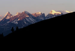
Photo: Blackfriars Peak (left) and Mount Quincy from the Icefields Parkway