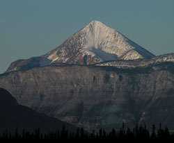
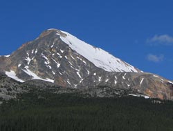
Photo: Looking southwest beyond The Pallisade to Pyramid Mountain from Highway #16
Pyramid Mountain
- 2766 m (9,075ft)
- Naming History
Located in the Athabasca River Valley; 4.5 km northwest of Pyramid Lake
Range: Victoria Cross
Province: Alberta
Park: Jasper
Headwater: Athabasca
Major Valley: Athabasca
Visible from Highway: 16, 93N
Named by: James Hector
Named for: The angle of mountain''s smooth, even slopes reminded Hector of a pyramid when he first saw it from the Athabasca River Valley to the east of the mountain.
Pyramid Mountain is the highest peak in the vicinity of Jasper Townsite. From Disaster Point, downstream on the Athabasca River from the peak, it is perfectly symmetric, with long evenly sloped ridges to the north-west and south-east. Snow tends to accumulate on the face which is seen from Disaster Point and generally lingers into mid-summer providing a striking contrast to the other nearby peaks. The mountain is also part of the view from the Icefield''s Parkway, to the south of Jasper but it is not nearly as outstanding as from Disaster Point where it is clearly one of the classic peaks of the Rockies. The mountain was first climbed by Rev. George Kinney and Conrad Kain. Pyramid Mountain suffered some abrupt erosion when the elevation of the mountain was reduced by ten metres in order to place a telecommunciations tower is now located on the summit. The tower was removed in 2004. Prior to James Hector's visit, the mountains was previously known as Priest''s Rock and the name remained in use for a while afterwards. In their book, "The Northwest Passage by Land," Milton and Cheadle describe their trip through the mountains in 1863, writing, "To the west, the Priest's Rock, a pyramid of ice, shone brightly above a dark pine-clad hill. . ." The peaks of the Victoria Cross Range are gently contoured and have a reddish-orange hue to them that comes from the oxidization of iron minerals that are found in the rock that forms much of this range. They are of Pre-Cambrian age, the rock being significantly older than the mountains to the south. Most are made of rock that was formed over a billion years ago. Composed largely of gritstone (sandstone, with the addition of grains of feldspar and mica) and slate, they are "softer" than those to the south and erode more easily, leaving a more rounded and worn profile. They are similar in age and in composition to the mountains in the very southern part of the province from the Castle River to Waterton National Park. THE PYRAMIDS OF THE CANADIAN ROCKIES There are at least seven mountains in the Canadian Rockies that have been known as "Pyramid." Only two officially carry the name, a third having had the name removed in order to avoid confusion with the other "Pyramids.” Peter Fidler was the first European to enter the Canadian Rockies and the first to name a peak. He noted in his journal on December 7, 1792 that he saw a, “remarkable high cliff…very much resembling a pyramid –from which very near resemblance I shall call it by that name.” He measured bearings to the feature and used it to calculate his position. It is likely that he was referring to what we now know as Mount Glasgow in the headwaters of the Elbow River. While travelling in the Bow River Headwaters near White Man Pass in 1845, Catholic priest/explorer Pierre-Jean De Smet wrote, "The valley is bounded on either side by a succession of picturesque rocks, whose lofty summits, rising in the form of pyramids, lose themselves in the clouds." On his map he noted only one of these, naming it "The Pyramid." This must have been the peak now known as Mount Assiniboine. The best known of the "Pyramids" is located nine kilometres north of Jasper. Its near-perfect triangular shaped profile when viewed from the east must have impressed James Hector of the Palliser Expedition who named the mountain in 1859. Although the mountain's slopes from this angle are similar to those of the Egyptian pyramids, the peak lacks the three-dimensional aspect that a true pyramid requires. Mount Chephren was originally named Pyramid Mountain by Norman Collie in 1897. At the same time he named its neighbour, which was covered in snow, White Pyramid. Pyramid Mountain, in contrast, had very little snow. In 1918 the Interprovincial Boundary Commission decided that Pyramid Mountain's name must be changed in order to avoid confusion with the Pyramid Mountain near Jasper. J. Monroe Thorington, a prominent mountaineer and author of the era, liked the association of the peak with the pyramids of Egypt and recommended the name Mount Chephren. Chephren, or Khafre, was the fourth pharaoh of the Fourth Dynasty of Egypt and built the second of the three Great Pyramids. White Pyramid's name was thought to be different enough from the Pyramid Mountain near Jasper and that name was retained. In 1892, Arthur Coleman named the fourth highest peak in the Rockies “Pyramid.” It was subsequently renamed Mount Clemenceau by the Interprovincial Boundary Commission in 1919 after Georges Clemenceau, the President of France during the final years of the First World War. Mount McPhail, in the upper Highwood Valley, was known locally as "The Pyramid" until it was officially named by the Boundary Commission in 1918. The surveyors at that time were influenced by the number of Canadian casualties during the First World War and named the peak to honour N.R. McPhail, a member of the Surveyor General's staff, who was killed in action in 1917. Of the seven mountains that have carried the name "Pyramid," Mount Glasgow, Mount McPhail, and Mount Assiniboine are the closest to the correct three-dimensional shape when viewed from the appropriate angles, but they are among those that never, officially at least, have carried the name.
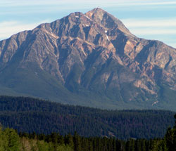
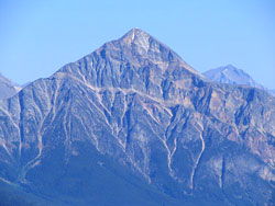
Photo: Looking north to Pyramid Mountain from the Icefields Parkway
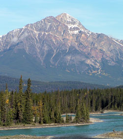
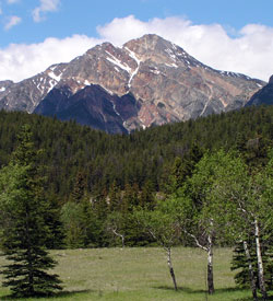
Photo: Looking north to Pyramid Mountain from the Athabasca River Bridge on the Icefields Parkway
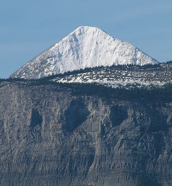
Looking southwest beyond The Pallisade to Pyramid Mountain from Highway #16
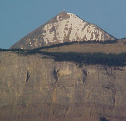
Looking southwest beyond The Pallisade to Pyramid Mountain from Highway #16 (Note the communications tower that was removed in 2004)
Looking north to Pyramid Mountain from the Whistlers (courtesy Sonny Bou)
Looking north to Pyramid Mountain from the Maligne Lake Road
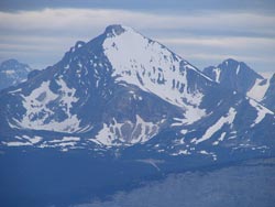
Looking southwest to Pyramid Mountain from Cinquefoil Ridge (courtesy Sonny Bou)
Looking west? to Pyramid Mountain (courtesy Sonny Bou)