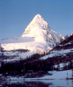
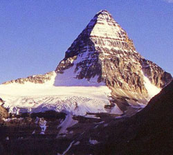
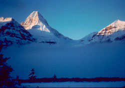
Photo: Looking south to Mount Assiniboine from Sunburst Lake (courtesy Ken Jones)
Mount Assiniboine
- 3618 m (11,871ft)
- First Ascent
- Naming History
- Hiking and Trails
Located on the continental divide at the head of Marvel Lake Valley; head of Assiniboine Creek
Province: Alberta/BC
Park: Banff/Assiniboine
Headwater: Bow/Kootenay
Visible from Highway: 93S, 742
Ascent Party: James Outram
Ascent Guide: C. Bohren, Christian Hasler sr.
Named by: George Dawson
Named for: The name is that of the Stoney Indians or Assiniboines.
Journal Reference: App 10-48; AJ 20-545
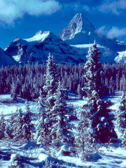
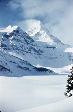
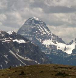
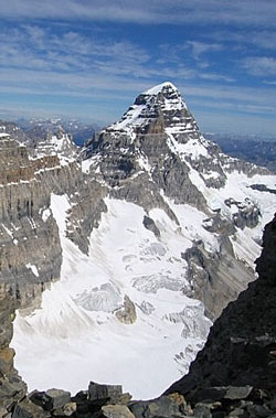
James Outram was the first man to reach the summit of Mount Assiniboine. He summarized the significance of this well known mountain when he wrote, "Its massive pyramid forms a conspicuous landmark from almost every considerable eminence for scores of miles around, towering fully 1500 feet above its neighbours, and by its isolation no less than by its splendid outline commanding attention and admiration." Although it can only be seen from one relatively lightly travelled roadside location in Alberta, Mount Assiniboine has become one of the most recognized mountains of the Rockies. This is undoubtedly because of its distinctive pyramidal shape as well as the lovely glacier and lake which lie below it when viewed from its most photographed angle. Christened "The Matterhorn of North America" by early travellers, its profile is classic. The peak is visible from Buller Pond on the Smith-Dorrien Trail. From this viewpoint, it is the mountains height and massiveness which are most impressive and the "Matterhorn like" shape does not present itself. The east-facing cliffs of Mount Assiniboine rise over 1700 metres above the valley below. A second roadside viewpoint is from Highway #93 in Kootenay National Park. An outstanding view of its distant summit may be seen from the Simpson River, 3.4 km north of the Simpson River footbridge or 2.7 km south of Verdant Creek (at Vermilion Crossing or Kootenay Park Lodge). For those who hike and climb to the higher elevations, the mountain's easily identified shape together with the fact that it towers above its neighbours, makes Assiniboine the most easily recognized of distant peaks. It is located on the Continental Divide, with Banff National Park to the east and Mount Assiniboine Provincial Park to the west. With an elevation of 3618 metres, Mount Assiniboine is the tallest mountain south of the Bow Valley, and one must travel north to the area of the Columbia Icefield to find a higher peak. "The monuments of Cheops and Chephren dwindle into nought before this gigantic architectural cliff of nature." These words were written by the Catholic priest/explorer Pierre-Jean Pierre-Jean De Smet in 1845 while he was camped at what is now known as White Man Pass. Pierre-Jean De Smet was probably the first non-native to see the mountain and he, like everyone who has seen it since, was obviously very impressed. The mountain was named in 1885 by George Dawson who first saw it from Copper Mountain on the south side of the Bow Valley west of Banff. According to Ken Jones who was the first warden at Mount Assiniboine Provincial Park, when Dr. Dawson first saw the peak from Copper Mountain there was, as is often the case, a plume of cloud trailing from the summit. This reminded him of the plumes of smoke that he had seen from the teepees of the Assiniboine Indians and this led to his choice of the name Mount Assiniboine. In 1893 Tom Wilson led the first group to the base of Mount Assiniboine. Robert Barrett was the client and he undoubtedly was hoping to make the first ascent but no attempt was made to climb the mountain probably because the trip was undertaken late in the season. In a letter to Tom Wilson some years later after visiting the Himalayas, Barrett wrote, "K2 at 28,000 feet didn?t look as high and imposing and terrible as Assiniboine when you and I finally won through to where we could get a look at him." In 1895 Barrett returned to the Mount Assiniboine area with Walter Wilcox, J.F. Porter, and guide Bill Peyto. Wilcox wrote that, "Great interest had aroused tourists in the summer of 1895 by reports of a remarkable peaks south of Banff named Mt. Assiniboine. According to current accounts it was the highest mountain so far discovered between the international boundary and the regions of Mount BrownMount HookerEdward Whymper, the famous English climber who made the first ascent of the Matterhorn, was to visit the Rockies with his own Swiss guides there was talk that he would attempt it even though he was sixty-two at the time. However Whymper did not attempt the mountain and it was James Outram, together with Swiss guides Christian Bohren and Christian Hasler sr. who were successful in 1901. It was Assiniboine's remoteness, together with the fact that snow and ice on the mountains can make in virtually unclimbable for significant portions of the summer, that resulted in its first ascent being so late given the mountain's significance. Of Mount Assiniboine, James Outram wrote, "The peak is grandest from its northern side. It rises, like a monster tooth, from an entourage of dark cliff and gleaming glacier, 5000 feet above the valley of approach; the magnificent triangular face, barred with horizontal belts of perpendicular cliff and glistening expanses of the purest snow and ice, which constitutes the chief glory of the mountain, soaring more than 3000 feet directly from the glacier that sweeps its base. On the eastern and the southern sides the walls and buttresses are practically sheer precipices 5000 to 6000 feet in vertical height, but the contour and character of the grand northen face more than compensate for the less sheer and lofty precipices." In celebration of the one hundredth anniversary of the first ascent of Mount Assiniboine Christian Bohren's grand-daughter Lonnie, together with Sepp Renner of Mount Assiniboine Lodge and two others, climbed the mountain on August 27th, 2001. Lawrence Grassi completed the first solo ascent of Mount Assinibine in 1925. THE PYRAMIDS OF THE CANADIAN ROCKIES There are at least seven mountains in the Canadian Rockies that have been known as "Pyramid." Only two officially carry the name, a third having had the name removed in order to avoid confusion with the other "Pyramids." Peter Fidler was the first European to enter the Canadian Rockies and the first to name a peak. He noted in his journal on December 7, 1792 that he saw a, "remarkable high cliff very much resembling a pyramid from which very near resemblance I shall call it by that name." He measured bearings to the feature and used it to calculate his position. It is likely that he was referring to what we now know as Mount Glasgow. During his trip though White Man Pass in 1845, Catholic priest/explorer Pierre-Jean Pierre-Jean De Smet wrote, "The valley is bounded on either side by a succession of picturesque rocks, whose lofty summits, rising in the form of pyramids, lose themselves in the clouds." On his map he noted only one of these, naming it "The Pyramid." This must have been the peak now known as Mount Assiniboine. The best known of the "Pyramids" is Pyramid Mountain. James Hector of the Palliser Expedition named the mountain in 1859. Although the mountain's slopes from this angle are similar to those of the Egyptian pyramids, the peak lacks the three-dimensional aspect that a true pyramid requires. Mount Chephren was named by Norman Collie in 1897. At the same time he named its neighbour, which was covered in snow, White Pyramid. Thorington, a prominent mountaineer and author of the era, liked the association of the peak with the pyramids of Egypt and recommended the name Mount Chephren. Chephren, or Khafre, was the fourth pharaoh of the Fourth Dynasty of Egypt and built the second of the three Great Pyramids. White Pyramid's name was thought to be different enough from the Pyramid Mountain near Jasper and that name was retained. In 1892, Arthur Coleman named the fourth highest peak in the Rockies "Pyramid." It was subsequently renamed Mount Clemenceau. Mount McPhail, in the upper Highwood Valley, was known locally as "The Pyramid" until it was officially named by the Boundary Commission in 1918. The surveyors at that time were influenced by the number of Canadian casualties during the First World War and named the peak to honour N.R. McPhail, a member of the Surveyor General's staff, who was killed in action in 1917. Of the seven mountains that have carried the name "Pyramid," Mount Glasgow, Mount McPhail, and Mount Assiniboine are the closest to the correct three-dimensional shape when viewed from the appropriate angles, but they are among those that never, officially at least, have carried the name.
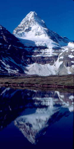
Photo: Looking south-southwest to Mount Assiniboine from near Lake Magog (courtesy Ken Jones)
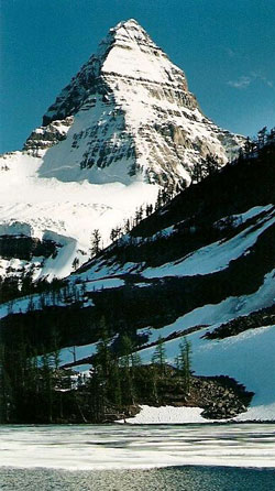
Looking south to Mount Assiniboine (courtesy Calvin Damen)
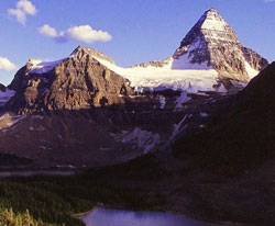
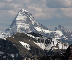
Looking south to Mount Magog (left) and Mount Assiniboine from The Nub (courtesy Calvin Damen)
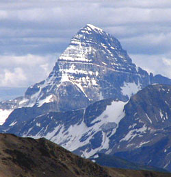
Looking south to Mount Assiniboine from the Nub Trail (courtesy Calvin Damen)
Looking to Mount Magog (left) and Mount Assiniboine (Ken Jones Collection)

Looking south to Mount Assiniboine (Ken Jones Collection)
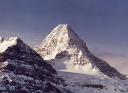
Mount Assiniboine with Mount Magog at left (Ken Jones Collection)
Looking southeast to Mount Assiniboine from Monarch Ramparts
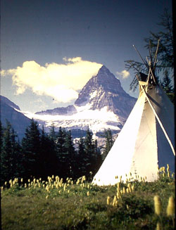
Looking south-southwest to Mount Assiniboine from Assiniboine Lodge (Ken Jones Collection)
Looking south to Mount Assiniboine from Mount Ishbel (courtesy Sonny Bou)
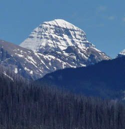
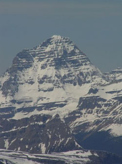
Looking south-southeast to Mount Assiniboine from Copper Mountain (courtesy Sonny Bou)
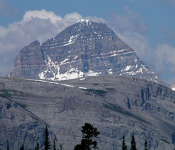
Looking southeast to Mount Assiniboine from Highway #93(S) near Vermilion Crossing
Looking west to Mount Assiniboine from the Smith-Dorrien Road
Looking south-southwest to Mount Assiniboine (Ken Jones Collection)
Looking west-southwest to Mount Assiniboine from Elys Dome
Looking west to Mount Assiniboine (courtesy Vern De Wit)
Looking north-northwest to Mount Assiniboine from Eon Mountain (courtesy Mark Nugara)