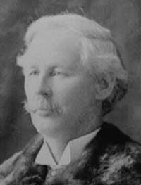
J.J. McArthur (Courtesy Whyte Museum, PA-42178)
James J. McArthur
(1856-1925) James Joseph McArthur was a Dominion Land Surveyor who worked in the Rockies (often with W.S. Drewry) from 1886 to 1893, completing a topographic survey of the mountains along the Canadian Pacific Railway's main line from Canmore to the summit of the Gold Range. William Stuart Drewry and Arthur St. Cyr were also D.L.S. surveyors and assisted him. He mapped 5000 square kilometres at a scale of 1:20,000 and contour interval of 100 feet. In the course of this detailed work, he made some of the earliest first ascents in the Rockies including such well known peaks as Mount Rundle, Mount Bourgeau, Mount Stephen and Big Sister). In a single year, 1889, McArthur ascended 43 peaks in excess of 2500 metres travelling 650 kilometres through very rugged terrain. A bulky, twenty pound camera and fifteen pound transit was carried to each summit. Between 1887 and 1893 he is said to have made some 160 ascents and travelled approimately 2400 kilometres. [Graeme Pole] The ascent of Mount Stephen was one of McArthur’s more challenging. Of a thirty metre "ice slide" near the top he wrote, "A slip on this glare surface meant death, and how we were to get down again caused us no little anxiety." Finally they reached the summit ridge which, "required all our nerve to crawl about one-eighth of a mile along the top of those half-balanced masses to the highest point of Mount Stephen 6,385 feet above the railway track." After this tremendous struggle, smoke from forest fires prevented any photography. Arthur O. Wheeler, a colleague of McArthur's who spent much of his professional life surveying the Continental Divide through the Rockies, wrote of McArthur, "He is a quiet, unassuming man, who has probably climbed more mountains in these regions than any other person, and has made a large number of first ascents. No flourish of trumpets ushered him forth to conquest, no crown of laurels awaited his victory; a corps of trained Swiss guides was not at hand to place his footsteps, to check his down-slidings, and select for him the surest road. With one assistanct, transit, and camera on back, many a perilous climb has been made, the rope only being used in the case of most urgent need. In all kinds of weather, through snow, over ice, and in pouring rain, many a difficult ascent has been accomplished, many privations encountered and much hardship endured; the only record being a few terse paragraphs in the Departmental Bluebook..." In his book, "Pushing the Limits -The Story of Canadian Mountaineering," Chic Scott refers to J.J. McArthur as "The first Canadian mountaineer." For many years J.J. McArthur was the authority on the Rockies west of Calgary. As well as Mount McArthur at the head of the Little Yoho Valley, a lake in the Lake O’hara area, which is one of the most beautiful in the Rockies, was named in his honour. Following his work in the Rockies, McArthur surveyed in the Yukon, spent time mapping the international border between Lake Superior and the Continental Divide and in 1917 became the Canadian Commissioner on the survey which delineated the border between Alaska and the Yukon. [See McArthur Pass; Mount McArthur; Mount Lady Macdonald]