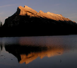
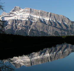
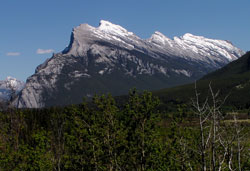
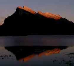
Photo: Looking southeast to Mount Rundle from Vermilion Lakes
Mount Rundle
- 2949 m (9,675ft)
- First Ascent
- Naming History
Located in the Bow River Valley northeast of Spray River; northwest buttress of White Man Gap
Province: Alberta
Park: Kananaskis/Banff
Headwater: Bow
Major Valley: Bow
Visible from Highway: 1, 742
Ascent Party: J.J. McArthur
Named by: John Palliser
Named for: Rundle, Reverend Robert (Rev. Rundle was a missionary who visited the Banff area during the 1840's.)
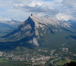
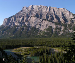
"Mount Rundle is my bread and butter mountain. I never tire of painting it, for it is never the same. In deep shadow in the morning, it borrows a warm glow from the setting sun at the end of the day. Its colour runs the gamut from orange to cold blue-grey, with overtones of violet and intervals of green." - Walter Phillips Clearly a favourite of this well known Canadian artist, Mount Rundle is perhaps the most recognized mountain in the Canadian Rockies and has probably been on more calendars than any other. The viewpoint from which most photographs are taken is five kilometres to the west with the Vermilion Lakes in the foreground. From Whiskey Creek Meadows a few kilometres to the east near the eastern entrance to the town of Banff, there is an excellent view of the rock layers which form its northeastern cliffs and some "textbook" geology is very clearly defined. The layers which form the steep, limestone cliffs at the top of the peak were named after the mountain itself and are known as the Rundle Formation. Of Mississippian age, they were formed approximately 330 million years ago. Below the Rundle, the gently sloping layers of more easily eroded shale was named after the town below and is known as the Banff Shale. The limestone cliffs below the Banff are Devonian in age. Known as the Palliser and Fairholme formations they are made of limestone which was formed 350 million years ago. The Mississippian and Devonian rocks were carried along the Rundle Thrust Fault which lies below the Devonian and above the Cretaceous and Jurassic rocks which are of a considerably younger age. Mount Rundle is really a small mountain range, stretching southeast for some twelve kilometres from the town of Banff to White Man Gap above the town of Canmore. There are seven distinct high points along the way, the third peak southeast of Banff being the highest. EEOR is the unofficial name of the southeastern most peak that rises above Whiteman's Gap. Robert Rundle was a Wesleyan missionary who worked among the natives from 1840 until 1848. He travelling to Canada from England in 1840 and worked with Father Pierre-Jean Pierre-Jean De Smet at Rocky Mountain House and Fort Edmonton before making his first visit to southern Alberta where he visited a Blackfoot camp on the Bow River. He returned to the Bow Valley in 1842, writing of the mountains, "What a spectacle to see them painted on the western sky at sunset!" Finally in 1844 he rode, "at last right into the midst of the Rocky Mountains" and attempted to climb one by himself, returning unsuccessful and exhausted and telling of loose rocks and, "steep slopes that fall away into nothingness." Returning in 1847, he held a service with a small group of natives in, "a small plain?quite in among the mountains?The scenery is most magnificent." It is thought that this was in the Whiskey Creek Meadows area near Banff. [Fraser] During the years he spent doing missionary work amongst the Cree and Assiniboine, Rev. Rundle became very involved in their culture He learned to speak Cree and even wrote hymns in the language. James Hector originally chose a descriptive name for the peak, "Terrace Mountain." But John Palliser, who had noted the influences of Rundle's work in the behaviour of the natives, was so impressed with the missionary that he decided to name the mountain in honour of Reverend Rundle. The mountain was first climbed in 1888 by James McArthur during his survey of the Bow Valley area. The east end of the mountain above Canmore and White Man Gap is unofficially known as "EEOR" after the donkey named Eeyore in A.A. Milne's book about Chrisopher Robin and his friends. The name comes from the initials of "East End Of Rundle" -EEOR. [Additional information: "A Hikers Guide to the Art of the Canadian Rockies" by Lisa Christensen]
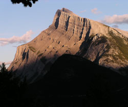
Looking southeast to Mount Rundle from the Mount Norquay ski area access road
Looking west-northwest to Mount Rundle (note avalanche) (Ken Jones Collection)
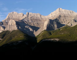
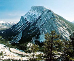
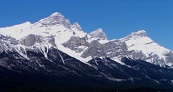
Looking west to the high point of Mount Rundle from the Trans-Canada Highway
Looking northwest to Mount Rundle from the Trans-Canada Highway
Looking southeast to Mount Rundle from Tunnel Mountain (courtesy Calvin Damen)
Looking south across Two Jack Lake to Mount Rundle

Looking south to Mount Rundle

Photo: Looking south to Mount Rundle from theTrans-Canada Highway
Looking southeast to Mount Rundle from Mount Norquay (courtesy Sonny Bou)
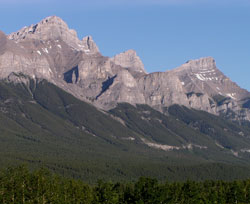
Looking southeast to Mount Rundle
Looking southeast to Mount Rundle
Looking northwest to Mount Rundle from the Trans-Canada Highway near Canmore
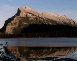
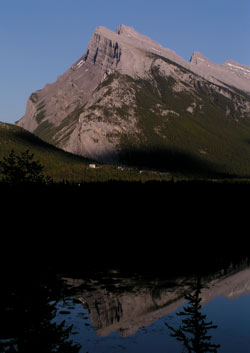
Looking southeast to Mount Rundle from Vermilion Lakes
Looking southeast to Mount Rundle from Vermilion Lakes
Looking southeast to Mount Rundle from Tunnel Mountain Drive near Banff Townsite