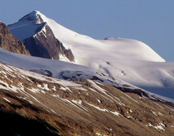
Photo: Looking northwest up the Yoho Valley from the Spiral Tunnels Viewpoint on Highway #1 to Mount McArthur
Mount McArthur
- 3015 m (9,892ft)
- First Ascent
- Naming History
- Hiking and Trails
Located in the upper Little Yoho and Amiskwi River Valleys
Province: BC
Park: Yoho
Headwater: Columbia
Visible from Highway: 1
Ascent Party: W.S. Drewry
Named by: Otto Koltz
Named for: McArthur, James J. (J.J. McArthur was a surveyor who mapped the Canadian Rockies in the vicinity of the Canadian Pacific Railway.) (see biog.)
An excellent viewpoint for this fine mountain is the parking lot for the Spiral Tunnel Viewpoint as one descends the "Big Hill" west of Kicking Horse Pass. The glacier descends from the summit and extends for some distance to the east, an impressive, dazzling white area on sunny summer days. James McArthur was a Dominion Land Surveyor who worked in the Rockies from 1886 to 1893, completing a topographic survey of the mountains along the Canadian Pacific Railway's main line from Canmore to the summit of the Gold Range. He mapped 5000 square kilometres at a scale of 1:20,000 and contour interval of 100 feet. In the course of this detailed work, he made some of the earliest first ascents in the Rockies including such well known peaks as Mount Rundle, Mount Bourgeau, Mount Stephen, and the highest of the Three Sisters (Big Sister). In a single year, 1891, McArthur ascended 43 peaks in excess of 2500 metres travelling 640 kilometres through very rugged terrain. A bulky, twenty pound camera and fifteen pound transit was carried to each summit. The ascent of Mount Stephen was one of McArthur's more challenging. Of a thirty metre "ice slide" near the top he wrote, "A slip on this glare surface meant death, and how we were to get down again caused us no little anxiety." Finally they reached the summit ridge which, "required all our nerve to crawl about one-eighth of a mile along the top of those half-balanced masses to the highest point of Mount Stephen 6,385 feet above the railway track." After this tremendous struggle, smoke from forest fires prevented any photography. Arthur Wheeler, a colleague of McArthur's who spent much of his professional life surveying the Continental Divide through the Rockies, wrote of McArthur, "He is a quiet, unassuming man, who has probably climbed more mountains in these regions than any other person, and has made a large number of first ascents... In all kinds of weather, through snow, over ice, and in pouring rain, many a difficult ascent has been accomplished, many privations encountered and much hardship endured; the only record being a few terse paragraphs in the Departmental Bluebook..." For many years J.J. McArthur was the authority on the Rockies west of Calgary. As well as Mount McArthur at the head of the Little Yoho Valley, a lake in the Lake O'Hara area, which is one of the most beautiful in the Rockies, was named in his honour. It is interesting to note that the first ascent of the mountain was completed by one of McArthur's assistants, William Stuart Drewery.
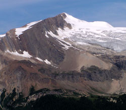
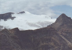
Photo: Looking northwest to Mount McArthur from the Iceline Trail
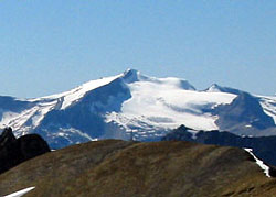
Looking northwest to Mount McArthur (Isolated Peak nearer at right) from Mount Bosworth (courtesy Sonny Bou)
Looking west to Isolated Peak (right) and Mount McArthur from Whaleback Mountain