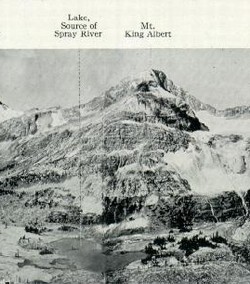
Photo: Looking west from Palliser Pass (Boundary Survey Report photo)
Mount King Albert
- 2987 m (9,800ft)
- First Ascent
- Naming History
Located on the continental divide in the Albert River Valley and at the head of the Spray River; west of Palliser Pass; 600 metres west of Mount Queen Elizabeth
Province: Alberta/BC
Park: Banff
Headwater: Bow/Kootenay
Ascent Party: G.A. Gambs, K.G. McClelland, T.B. Moffat, H.E. Sampson, D.R. Sharpe
Ascent Guide: Ernest Feuz
Named for: King Albert (The popular and progressive king of Belgium, King Albert was killed in a climbing accident in 1934.)
During the A.C.C. Camp at Palliser Pass in August 1922, Thos. B. Moffat, an enthusiastic and active member of the Alpine Club wrote of Ernest Feuz "assisting us from a most dangerous position" on Mount King Albert: "We had attempted to climb the peak but unfortunately rain made the rocks so dangerous that we could not make the peak and darkness overtook us before we could reach the snow again. Word was sent to camp and Ernest hastened to our relief. How he ever ascended in the darkness to our position with only the assistance of a small lantern, bringing us food & clothing and then assisted us to safety will always be a mystery to me." Mr. Moffat presented a pocketwatch to Ernest that was engraved as follows, "Presented to Ernest Feuz as a token of appreciation of the work done on King Albert; August 5, 1922 -T.B. Moffatt." The watch is now the property of the Whyte Museum of the Canadian Rockies.
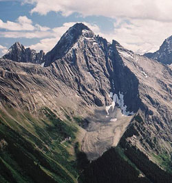
Looking southeast to Mount King Albert from White Man Peak (courtesy Calvin Damen)