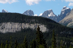
Photo: (l-r) Hall Tower, Engelhard Tower, Bison Tower, and un-named tower looking up Murchison Creek on Highway #11
Hall Tower
- 3215 m (10,548ft)
- First Ascent
- Naming History
Located north of the head of Totem Creek; easternmost tower on south portion of Mount Murchison
Province: Alberta
Park: Banff
Headwater: Saskatchewan
Visible from Highway: 11
Ascent Party: H.S. Hall
Ascent Guide: Edward Feuz jr.
Named by: W.L. Putnam
Named for: Hall, Henry Snow (Henry Snow Hall jr. made the first ascent of this tower in 1940. He was an official and first honourary president of the American Alpine Club.)
Mount Murchison was named by James Hector in 1858 after Sir Roderick Murchison who was at that time the director of the Geological Survey of Great Britain and had recommended that Hector be chosen as the geologist on the Palliser Expedition. In a letter written in 1859, Sir Murchison thanked Hector, "for attaching my name to this culminating point." The base of Mount Murchison covers an area measuring five km by seven km. There are two high points on the main summit (northwest and southeast). They are 700 metres apart. Seven "towers" in excess of 3050 metres: Engelhard Tower, Gest Tower, Feuz Tower, Bison Tower, Cromwell Tower, Hall Tower, and South East Tower lie to the southeast and have been unofficially named. It is a rather unique mountain and Bow Pass is probably the best point to get a feeling for its areal extent and the fact that it has so many individual summits of approximately the same elevation. It is said that the Indians believed that Mount Murchison was the highest peak in the Rockies. Mount Murchison stands to the south as the North Saskatchewan River turns towards the east at Saskatchewan River Crossing to begin cutting across the ranges towards the foothills. A massive feature, its base covers an area of five kilometres by seven kilometres. There are two high points on the main summit and seven "towers" in excess of 3050 metres. The natives passed alongside its base on a regular basis as they followed the North Saskatchewan River to and from Howse Pass with its connection to the Columbia Valley. It is said that they believed that Mount Murchison was the highest peak in the Rockies and, from their perspective, it certainly would have appeared to be. Looking northwest from the Icefields Parkway, Mount Murchison is first seen from Bow Pass and from this viewpoint its areal extent and the fact that it has so many individual summits of approximately the same elevation are apparent. The northwest facing aspect of the peak is best seen from the Icefields Parkway, immediately northwest of Saskatchewan River Crossing. An excellent view of the peak and a few of the spectacular towers appears to the east of Saskatchewan River Crossing on Highway #11 where Murchison Creek flows down from the peak to join the North Saskatchewan River. As James Hector descended the Mistaya Valley in September of 1858, he wrote that he, "got occasional peeps of a lofty peak to the east, which I named Mount Murchison, occupying such a central position among other high and precipitous mountains [the Murchison Towers] that we saw it only at intervals. The Indians say it is the highest mountain they know of..." Hector later wrote that, "Sir Roderick was pleased that such a "culminating point" had been named in his honour."
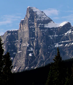
Photo: Looking up Murchison Creek to Hall Tower