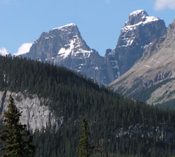
Photo: Looking up Murchison Creek to Bison Tower (left) and un-named tower from Highway #11
Bison Tower
- 3185 m (10,450ft)
- First Ascent
- Naming History
Located at the head of Bison Creek; northernmost tower on south portion of Mount Murchison
Province: Alberta
Park: Banff
Headwater: Saskatchewan
Major Valley: Mistaya
Visible from Highway: 11, 93N
Ascent Party: E. Cromwell, Georgia Engelhard
Ascent Guide: Edward Feuz jr.
Named by: W.L. Putnam
Named for: Bison Creek drains from several towers south of the main massif of Mount Murchison including this one.
Bison Tower is one of the towers on Mount Murchison. The mountain was named by James Hector in 1858 after Sir Roderick Murchison who was at that time the director of the Geological Survey of Great Britain and had recommended that Dr. Hector be chosen as the geologist on the Palliser Expedition. In a letter written in 1859, Sir Murchison thanked Hector, "for attaching my name to this culminating point." The base of Mount Murchison covers an area measuring five km by seven km. There are two high points on the main summit (northwest and southeast). They are 700 metres apart. Seven "towers" in excess of 3050 metres, Engelhard Tower, Gest Tower, Feuz Tower, Bison Tower, Cromwell Tower, Hall Tower, and South East Tower,) lie to the southeast and have been unofficially named. It is a rather unique mountain and Bow Pass is probably the best point to get a feeling for its areal extent and the fact that it has so many individual summits of approximately the same elevation. It is said that the Indians believed that Mount Murchison was the highest peak in the Rockies.
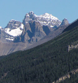
Photo: Looking north to (l-r) Bison Tower, Cromwell Tower, and Engelhard Tower from the Icefields Parkway