
Photo: Looking southeast to Mount Murchison from the Icefields Parkway
Mount Murchison
- 3333 m (10,936ft)
- First Ascent
- Naming History
Located southeast of the confluence of the Mistaya River with the NorthSaskatchewan; west of Murchison Creek; northwest of Totem Creek
Province: Alberta
Park: Banff
Headwater: Saskatchewan
Major Valley: Saskatchewan
Visible from Highway: 11, 93N
Ascent Party: J. Norman Collie, H.E.M. Stutfield, G.M. Weed
Ascent Guide: Hans Kaufmann
Named by: James Hector
Named for: Murchison, Sir Roderick Impey (Sir Murchison was a Scottish geologist who played a role in James Hector's appointment to the Palliser Expedition.)
This massive mountain was named by James Hector in 1858 after Sir Roderick Murchison who was at that time the director of the Geological Survey of Great Britain and had recommended that Hector be chosen as the geologist on the Palliser Expedition. In a letter written in 1859, Sir Roderick thanked Hector, "for attaching my name to this culminating point." A president of the Royal Geographical Society, Murchison was one of a group of pioneer geologists who, at the time of the Palliser Expedition, were attempting to classify the earth's sediments according to their character and age. The base of Mount Murchison covers an area measuring five km by seven km. There are two high points on the main summit (northwest and southeast). They are 700 metres apart. Seven "towers" in excess of 3050 metres: Engelhard Tower, Gest Tower, Feuz Tower, Bison Tower, Cromwell Tower, Hall Tower, and South East Tower lie to the southeast and have been unofficially named. It is a rather unique mountain and Bow Pass is probably the best point to get a feeling for its areal extent and the fact that it has so many individual summits of approximately the same elevation It is said that the Indians believed that Mount Murchison was the highest peak in the Rockies. Please note that there is a separate Peakfinder entry for each of the towers. Sir Roderick Impey Murchison (1792-1871)attended military college and fought in the Peninsular War. After becoming a renown fox hunter, he turned his attention to science, studying geology. Between 1825-1831 Murchison explored large parts of England, Scotland and France. Later he worked in Wales where he worked in founding the basic prinicples of the Silurian and Devonian. He later visited Russia, Scandinavia and Finland, studying the geology of Russian and the Ural Mountains. He became Director General of the Geologic Survey in Britain.
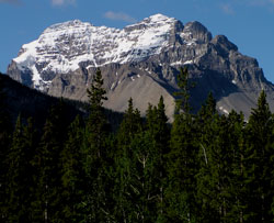
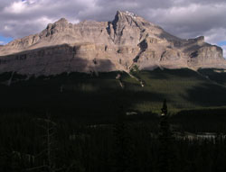
Photo: Looking south to Mount Murchison from Highway #11
Looking southeast to Mount Murchison from the Icefields Parkway
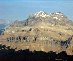
Looking northeast to Mount Murchison from Mount Sarbach (courtesy Sonny Bou)
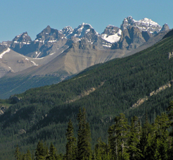
Looking north to Mount Murchison and Murchison Towers