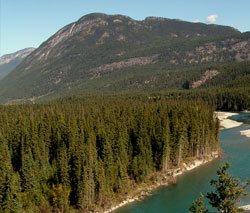
Photo: Looking northeast to Mount Grainger from near Canal Flats
Mount Grainger
- 1804 m (5,920ft)
- Naming History
50.1731N -115.724W
Located in the Kootenay River Valley, 5 km east of Canal Flats
Province: BC
Headwater: Kootenay
Major Valley: Kootenay
Visible from Highway: 95
Located in the Kootenay River Valley, 5 km east of Canal Flats
Province: BC
Headwater: Kootenay
Major Valley: Kootenay
Visible from Highway: 95
Year Named: 1923
Named by: Charles D. Walcott
Named for: The Grainger Ranch was located below the western slopes of this mountain.
Named by: Charles D. Walcott
Named for: The Grainger Ranch was located below the western slopes of this mountain.
This peak, or possibly Mount Glenn, is noted as Mount Sabine on the Palliser Expedition's 1865 map and on George Dawson's 1886 map. The peak currently known as Mount Sabine is located immediately north of the point where the Kootenay River enters the major valley just south of Columbia Lake. Thomas Blakiston referred to the peak now known as The Steeples but also referred to it as Mount Sabine. It appears that John Palliser chose to name "The Steeples" and transferred the name "Mount Sabine" to a point northeast of where the Kootenay River turns into the major valley south of Columbia Lake.