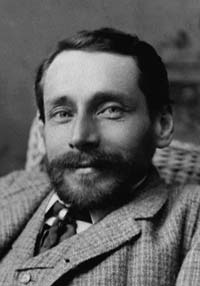
George Dawson (Courtesy National Archives of Canada, PA 26889)
George M. Dawson
(1849-1901) George Mercer Dawson, the son of the principal of McGill University, is said to have been one of the most outstanding scientists Canada has ever produced. His research and reports were remarkable in their breadth and thoroughness. He had a reputation for excellence, his maps being referred to as "a literal photograph of the country containing information phenomenally complete and accurate." This quality of work was a result of tremendous physical effort in the field despite his short stature complicated by a chronic chest weakness and a back humped by a childhood disease (Pott's Disease -tuberculosis of the spine) that stopped his growth. This man who charted vast areas of previously unmapped country in western Canada was the size of a boy of twelve. He was described as having a "cheerful, amiable disposition combined with an indomitable will and an insatiable passion for exploration and discovery." One of his first major projects was being involved with the International Boundary Survey of 1872 to 1876 that marked the border and undertook scientific studies along the way. The natural history was put under the direction of the 25 year old Dawson. During the course of the survey he gathered information that was eventually published as a 387 page "Report on the Geology and Resources of the Region in the Vicinity of the 49th parallel from the Lake of the Woods to the Rocky Mountains." This document established his scientific reputation. He became known as "Dr. George" and went on to become one of the most outstanding scientists Canada has ever produced, building the basis for much of the geological and botanical knowledge of western Canada. His native guide during this work referred to him as, "Skookum Tumtum" meaning "brave, cheery man." In 1874, Dr. Dawson is said to have made the first discovery of a dinosaur in Canada. The 1877 seson saw Dawson and his assistant R.G. McConnell (see Mount McConnell) exploring northern British Columbia and the headwaters of the Yukon River, during which they made an arduous circuit by separate routes, on foot and by boat, of an area of 63,200 square miles that had been previously unknown except for the accounts of a few prospectors and Indians. During 1883 and 1884 George Dawson travelled extensively through the Rockies conducting the first Government of Canada survey of the southern Rockies. Following the Palliser Expedition, any surveying work in the mountains had been sponsored by the Canadian Pacific Railway and focused on finding a route through the mountain barrier for the railway. Dr. Dawson's task was more general in nature, to determine the courses of the major rivers and the locations of the main peaks and passes. His first summer's work in the mountains began in early July and by the end of the season he had travelled through the country south of Crowsnest Pass, to the headwaters of the Oldman River, up the Kootenay and Columbia Valleys to the present site of Golden, and then through the Kicking Horse Pass and down the Bow River Valley. His second summer's studies began in early June and took him from the Bow Valley to the headwaters of the Kananaskis River and south again to the Crowsnest Pass, returning to the Bow Valley in late July. The month of August was spent covering the area from south of Mount Assiniboine to the Kicking Horse Pass. During September his party studied the area north of Castle Junction to the Red Deer Valley and west to the headwaters of the Bow River. Approximately one thousand kilometres were travelled during the two seasons, a remarkable effort considering the lack of trails. As well, Dr. Dawson would have constantly been stopping and taking side trips for his scientific work and it must be remembered that he had some significant physical limitations. George Dawson’s map of the Canadian Rockies (from the U.S. border to the Red Deer Valley and Kicking Horse Pass) was published in 1886 and was based on his field work completed during 1883 and 1884. The map included geological surface information and six complete geological cross-sections through various points in the Rockies. He was assisted by J.B. Tyrell ( Mount Tyrrell ) in 1883 and J. White ( Mount White ) in 1884. R.G. McConnell ( Mount McConnell ) contributed his work in the Bow Valley that was done in 1885. As a thank you to his assistants, Dawson named three peaks in the lower headwaters on the Red Deer Valley near what is known as Scotch Camp. In addition to his geological work, Dawson was keenly interested in the languages and cultures of North American Indians. While studying the coal deposits of the Queen Charlotte Islands in 1878, he studied, photographed, and prepared a comprehensive report on the Haida Indians. He also published papers about the Indians of the Yukon, northern British Columbia, and Vancouver Island and the Shuswap people of central British Columbia. Dr. Dawson's work took him to many other parts of the country. His name is to be found on the maps and in numerous reports ranging from the Alberta Rockies, through British Columbia to the Queen Charlotte Islands, and in the Yukon. Although he was appointed director of the Geological Survey of Canada in 1895, DawsonÍs interests and studies extended beyond geology into many other fields of science. His field journal even contained the occasional poem including this one with a geological flavour: Contorted bed, of unknown age, My weary limbs shall bear, Perhaps a neat synclinal fold At night shall be by lair. Dips I shall take in unnamed streams, Or where the rocks strike, follow Along the crested mountain ridge Or anticlinal hollowƒ Where long neglected mountains stand Just crumbling into shreds And laying bare on every hand The treasures of their beds. Dr. Dawson died very suddenly in 1901.