Photo: Looking west across the Spray Valley to White Man Mountain, Mount Leval nearer at right (Interprovincial Boundary Report photo)
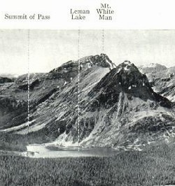
White Man Mountain
- 2977 m (9,768ft)
- Naming History
Located on the continental divide at the head of the Cross River and the head of Whiteman Creek; southeast buttress of Whiteman Pass;
Province: Alberta/BC
Park: Banff
Headwater: Bow/Kootenay
Named by: George Dawson
Named for: The mountain stands to the south of White Man Pass and takes its name from the pass.
The "white man" for whom White Man Pass and subsequently White Man Mountain was named was Pierre-Jean Pierre-Jean De Smet who camped on the pass in 1845. He is said to have built a cross on the summit of the pass. This is the source of the name for Cross Creek whose headwaters are on the BC side of the pass. The natives began referring to the pass as White Man and referred to it as such to John Palliser who included it on his map following the Palliser Expedition of 1858-1860. Father Pierre-Jean De Smet was a Catholic missionary who travelled through much of the Canadian Rockies in 1845 and 1846. He regularly wrote long and interesting letters to his "Superior" which are delightful descriptions of the landscape and the natives which he was working with. His writings, entitled "Oregon Missions and Travels over the Rocky Mountains," were published in book form in 1847. Much of the book is concerned with his work as a priest but it also contains some interesting references to the mountains. The map that accompanied the book covers a vast area from 44 degrees to 54 degrees latitude and from the Pacific Ocean to well east of the front ranges of the mountains. Although it is primarily concerned with rivers, it does note the locations of several mountains that must have been considered to be particularly noteworthy at that time. One of these is the legendary Mount Brown with its elevation of 16 000 feet. Another is "Devil's Nose" which probably was the peak we now know as Devil's Head. Also noted on the map is "The Pyramid" which was almost certainly the peak now known as Mount Assiniboine. The book also contains many amusing anecdotes, many of which describe incidents involving his size and his somewhat limited skills in horsemanship and wilderness travel. He was said to have been a popular, jovial man but considerably overweight and negotiating between the trees on horseback was difficult for him at times. He wrote, "I have a little word of advice to give all who wish to visit these latitudes. At the entrance of each thick forest, one should render himself as slender, as short, and as contracted as possible...Not withstanding these precautions, it is rare to escape without paying tribute in some manner to the ungracious forest. I one day found myself in a singular and critical position: in attempting to pass under a tree that inclined across the path, I perceived a small branch in form of a hook, which threatened me. The first impulse was to extend myself upon the neck of my horse. Unavailing precaution! It caught me by the collar of my surtout, the horse still continuing his pace. Behold me suspended in the air, struggling like a fish at the end of a hook. Several respectable pieces of my coat floated, in all probability, a long time in the forest, as an undeniable proof of my having paid toll in passing through it. A crushed and torn hat, an eye black and blue, two deep scratches on the cheek, would, in a civilized country, have given me the appearance rather of a bully issuing from the Black Forest, than a missionary."