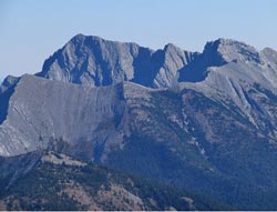
Looking southeast to Mount Techumseh (left) and Phillipps Peak from Mount Erickson (courtesy Sonny Bou)
Phillipps Peak
- 2500 m (8,203ft)
- Naming History
Located on the continental divide one km southwest of Mount Tecumseh; north buttress of Phillipps Pass
Range: High Rock
Province: Alberta/BC
Headwater: Oldman/Kootenay
Major Valley: Crowsnest
Visible from Highway: 3
Named for: Phillipps, Michael (As an employee of the Hudson Bay Company, Michael Phillips was the first white man to visit the Crowsnest Pass area.)
Please note that there is Phillips Peak in southeastern BC near the Elk Valley, Phillipps Peak near Crowsnest Pass, and Mount Phillips near Mount Robson. Phillipps Peak is actually a high point or shoulder of the long southwest ridge that descends from Mount Tecumseh. This high mountain to the north of Crowsnest Pass has had a complex history in terms of its name. It was originally called Mount Wilson but the members of the Boundary Survey had the name changed to avoid confusion with the Mount Wilson next to the North Saskatchewan River near the Icefields Parkway. The mountain was also known locally as "The Sleeping Giant," as its profile was thought to resemble one. For a period of time it was known by this name as well Phillipps Peak and was also called Mount Tecumseh. In 1960 the name Tecumseh was confirmed but the westerly, and slightly lower high point on the mountain was named Phillipps Peak. Tecumseh, which means "Shooting Star," was a Shawnee Indian brave who was made a brigadier general and led his warriors to fight alongside Sir Isaac Brock against the American invaders in the War of 1812. It is unusual for a mountain in western Canada to be named after events in eastern Canada which took place almost one hundred years prior to settlement here. It is likely that the mountain was named after another place or person which had previously been named after the Indian who fought with Brock. Michael Phillipps was a Hudson Bay Company clerk in charge of a post at the mouth of the Wild Horse River. While searching for gold in 1873 he became the first white man to visit the Crowsnest Pass area and the mountain which is actually the southwest shoulder of Mount Tecumseh was named in his honour. The mountain is at the southern end of the High Rock Range which forms the Continental Divide for almost 100 km from Mount Tecumseh to Mount Muir in the Upper Highwood Valley. To the north of Mt. Tecumseh there is a break in the range formed by Deadman Pass, only 700 feet higher than Crowsnest Pass. North of Deadman Pass we can see the High Rock Range rising again and forming the southern slopes of Allison Peak.
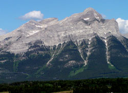
Photo: Phillipps Peak (left) and Mount Tecumseh (right) from Highway #3
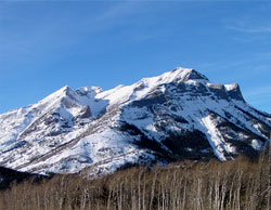
Photo: Phillipps Peak (left) and Mount Tecumseh (right) from Highway #3