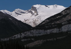
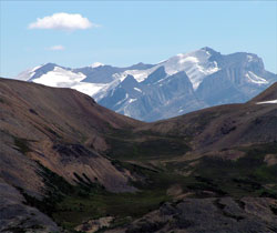
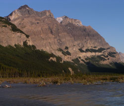
Photo: Looking west to Mount Wilson and the Wilson Icefield from Highway #11
Mount Wilson
- 3260 m (10,696ft)
- First Ascent
- Naming History
Located in the North Saskatchewan River Valley north of Saskatchewan River Crossing and southeast of Rampart Creek; west of Owen Creek
Province: Alberta
Park: Banff
Headwater: Saskatchewan
Major Valley: Saskatchewan
Visible from Highway: 11, 93N
Ascent Party: James Outram
Ascent Guide: Christian Kaufmann
Named by: J. Norman Collie
Named for: Wilson, Tom (Tom Wilson was an early explorer, outfitter, and guide in the Canadian Rockies.) (see biog.)
The mountain named in honour of Tom Wilson lies just to the north of the point where the North Saskatchewan River turns from the long, continuous valley which the Icefields Parkway follows to flow east towards the front ranges and the prairies. Covering a large area, the peak's high cliffs stretch for eleven kilometres and curve, paralleling both the Icefield Parkway north of Saskatchewan River Crossing and Highway #11 to the east. An early traveller wrote, "I don't like Mount Wilson. I once travelled around its base for two days and it seemed as though I should never get away from it." James Outram agreed, writing, "The frowning ramparts of Mount Wilson are imposing, but fifteen miles of them pall eventually on the most enthusiastic." The northeastern slopes of Mount Wilson feature a large snowfield which appears as the summit of the mountain when it is viewed from Bow Pass. As one descends the Icefield Parkway towards the mountain the glacier disappears. The entire glacier may be seen from the David Thompson Highway, ten kilometres to the east of the junction with the Icefields Parkway. North of Saskatchewan River Crossing, numerous, slender waterfalls tumble down Mount Wilson's southwest facing cliffs (the ramparts referred to by Outram) as the snow and ice melt during the early summer. As one approaches the bottom of the Saskatchewan Valley and Mount Wilson while northbound on the Icefields Parkway a large spring may be seen flowing down one of the gullies on the right hand side of the mountain. Its source must be melting snow and ice near the summit of the peak. These waters must descend through the mountain through solution channels in the limestone before gushing out of the side of the mountain as a good-sized stream. The first ascent of Mount Wilson was the last climb in James Outram's very successful summer of 1902 during which he recorded first ascents of eight major peaks including Mount Columbia. Of the view from Mount Wilson he wrote that, "The view was one of the most delightful of the year. Besides the new country now displayed to the north and east, the panorama furnished a complete resume of our entire trip, and no other mountain could have offered so perfect an ideal for a consummation of the summer's mountaineering... The vast sea of mountains, in all their majesty of might, the attendant valleys, filled with treasures of most perfect beauty, glacier and forest depth, sparkling stream and flower-decked glade, have graven with imperishable strokes upon my memory a record that will be a never-ceasing joy throughout life." The mountain was named by Norman Collie in 1898 after the most renown of the early outfitters of the Canadian Rockies. Tom Wilson (1859-1933) During the summer of 1882 a former member of the North West Mounted Police and his Stoney Indian companion known as "Gold Seeker" journeyed westward up the Bow Valley. Tom Wilson was employed by the Canadian Pacific Railway and was working for Major A.B. Rogers, chief engineer of its Mountain Division, who was conducting surveys in the valley. While camped, the sound of distant avalanches were heard and Gold Seeker explained to Tom that the sounds came from a mountain above the "Lake of Little Fishes." The following day the two climbed out of the valley and Tom Wilson became the first non-native to visit what we now know as Lake Louise. Tom named the lake Emerald Lake, a name which eventually became attached to another lake which Tom discovered. Following his work with the railway, which included his being in the famous "Driving of the Last Spike" photograph at Craigellachie in November of 1885, Tom Wilson became one of the most reknown of the early outfitters in the Rockies. He led many pioneering explorations into remote areas such as Mount Assiniboine, the Yoho Valley, and the Saskatchewan River Headwaters. Many of his assistants, such as Bill Peyto and Jimmy Simpson, went on to become legendary guides in their own right. In 1904 he sold his outfitting business. Retaining ownership of many of his horses, he continued to live in Banff but spent most of his time raising horses in the Kootenay Plains, a unique area of prairie like grassland in the valley of the North Saskatchewan River, downstream from Mount Wilson. One winter Tom was at his horse ranch and as Christmas Day approached he decided to join his family in Banff for dinner. Despite the fact that conditions were not favourable, he set off travelling up the Siffleur River. Arthur Wheeler described the trip as involving, "a snowshoe tramp alone of seventy miles through lonely tree-clad valleys, through rock-bound gorges and over wind-swept passes, where all nature lay stark and stiff in the icy grip of winter." At one point he fell through a snowbridge during a fierce windstorm and had great difficulty drying his wet socks and moccasins. "It was drifting and snowing so hard that the snow covered my sox and moccasins as fast as I could wring them dry, and, owing to the fierce wind, the flames leaped in every direction, making it impossible to get near the fire, so at half past nine I gave it up, put on my wet footgear and snowshoes and started down the valley. I could not see and felt the way with a stick... It kept the circulation going." When daylight came he was in heavy timber and was able to dry his footgear. The last three days of his journey were made without food. Tom wrote, "...the last day I could only make about fifty yards without resting, and my back tracks did not leave a very straight line. The chief trouble I had was to keep from going to sleep; it would have been so much easier to quit than to go on." Tom Wilson was active in the mountains until 1920 when he moved to Vancouver. However, the old lure proved too strong and he returned to spend the years from 1927 to 1933 providing "local colour" for the CPR by entertaining guests at the Banff Springs Hotel with stories of the old days in the Rockies. [Additional information: "Diamond Hitch" by E.J. Hart] [Additional information: "Christmas Dinner" by Arthur Wheeler and Tom Wilson; "Tales of the Canadian Rockies" edited by Brian Patton]
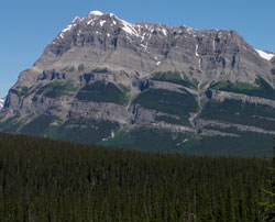
Photo: Looking west-northwest to Mount Wilson from the Icefields Parkway
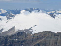
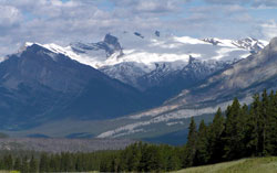
Looking southwest to Mount Wilson from Mount Cline (courtesy Marta Wojnarowska)
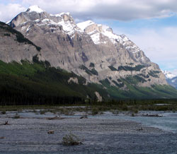
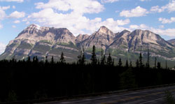
Looking southeast to the ramparts of Mount Wilson from the Icefields Parkway
Looking southeast to Mount Wilson from Parker Ridge
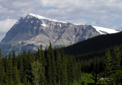
Looking west-northwest to Mount Wilson from the Icefields Parkway
Looking west to Mount Wilson and the Wilson Icefield from Highway #11
Looking west-northwest to Mount Wilson from the Icefields Parkway
Looking north-northwest across the North Saskatchewan River to Mount Wilson from the Icefields Parkway
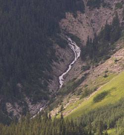
Looking north-northwest to the big spring on Mount Wilson
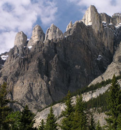
Looking northeast to pinnacles (very hard quartzite of the Mount Wilson formation) on the ramparts of Mount Wilson from the Icefields Parkway (