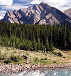
Photo: Looking south to Mount White from the confluence of Divide Creek and the Red Deer River (courtesy Aaron Osicki)
Mount White
- 2755 m (9,039ft)
- Naming History
Located in the Red Deer River Valley opposite Mount Tyrrell
Range: Bare
Province: Alberta
Park: Banff
Headwater: Bow
Major Valley: Red Deer
Named by: George Dawson
Named for: White, James (An assistant to Dr. Dawson in his surveys of southern Alberta, James White was later appointed Chief Geographer of the Department of the Interior.)
The mountain is referred to as White's Mountain on George Dawson's 1886 map. George Dawson's map of the Canadian Rockies (from the U.S. border to the Red Deer Valley and Kicking Horse Pass) was published in 1886 and was based on his field work completed during 1883 and 1884. The map included geological surface information and six complete geological cross-sections through various points in the Rockies. He was assisted by J.B. Tyrrell (see Mount Tyrrell) in 1883 and J. White in 1884. R.G. McConnell (see Mount McConnell) contributed his work in the Bow Valley that was done in 1885. As a thank you to his assistants, Dawson named three peaks in the lower headwaters on the Red Deer Valley near what is known as Scotch Camp. Please see: Mount Tyrrell and Mount McConnell.

Photo: Looking south-southeast to Mount White from Scotch Camp in the Red Deer River (courtesy Aaron Osicki)