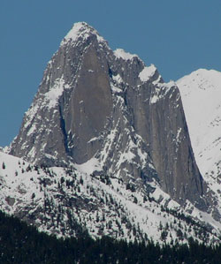
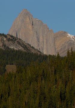
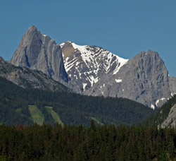
Photo: Looking west-northwest to Mount Louis from the Trans-Canada Highway at the former site of the Town of Anthracite, 10.5 km east of Banff
Mount Louis
- 2682 m (8,800ft)
- First Ascent
- Naming History
Located in the Forty Mile Creek Valley southwest of Mount Brewster
Range: Sawback
Province: Alberta
Park: Banff
Headwater: Bow
Visible from Highway: 1
Ascent Party: A.H. MacCarthy
Ascent Guide: Conrad Kain
Named for: Stewart, Louis B. DLS (Louis surveyed in Banff Park in 1904 with his father, George Stewart, the first Park Superintendent. He travelled in the Rockies with Arthur Coleman in 1892 and 1903. Later Louis became a professor at the University of Toronto.)
At 2682 metres, the mountain is not a high one nor does it have a glacier or snowfield. It is Louis's classic profile and vertically dipping, smooth faces which give the mountain its appeal and the summit its sense of remoteness and inaccessibility. Following the first ascent of the mountain in, the now legendary guide Conrad Kain looked up at the peak and said to his client, "Ye Gods, Mr. MacCarthy, just look at that; they never will believe we climbed it." During the summer of 1916, Kain and Albert MacCarthy had planned to spend a day horseback riding and while in the vicinity of Mount Louis, undertake a "preliminary reconnaissance." However when Conrad began searching for a route on the lower cliffs, MacCarthy followed him up and this "preliminary reconnaissance" developed into the first ascent of the mountain. The vertically dipping limestone of Mount Louis is Devonian in age. What makes the mountain so special are the extremely steep cliffs which surround the peak. From all angles including the one from Anthracite the mountain appears, at least to those who are not "technical" rock climbers, to be un-climbable. Mount Louis is one of a group of three peaks which are part of the Sawback Range. They are composed of rock layers which were, of course, originally horizontal but are now oriented vertically. Mount Edith is the southernmost of the group of three but is hidden behind Mount Norquay when viewing Mount Louis from Anthracite. To the north of Louis lies Mount Fifi, somewhat similar to Louis but shorter and with less steeply sloped sides. In the background between Louis and Fifi is a more gently sloped portion of the Sawback Range. Mount Louis is most striking in the winter when all the surrounding mountains, including the one behind it, are covered with snow but Louis's vertical cliffs remain bare, producing a dramatic contrast. Mount Edith, Mount Louis, and Mount FifiEdith Pass. The pass provides views of the three peaks and a park surveyor named them after the two hikers and the dog.
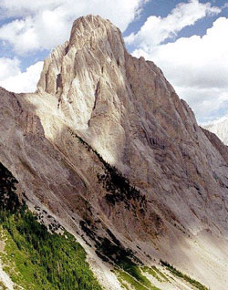
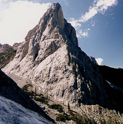
Photo: Looking north to Mount Louis from Cory Pass (courtesy Bennett Wong)
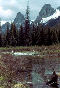
Looking southwest to Mount Louis (centre) and Mount Fifi (right) from Forty Mile Creek
Mount Louis (courtesy Steve Tober)
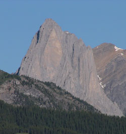
Looking west to Mount Louis from the Trans-Canada Highway near Banff
Looking west to Mount Louis from Tunnel Mountain Drive near Banff Townsite
Looking south east to Mount Fifi (left) and Mount Louis with Mount Rundle beyond (courtesy Sonny Bou)
Looking northwest to Mount Louis from near Edith Pass (courtesy Calvin Damen)
Looking west-northwest to Mount Louis (left) and Mount Fifi