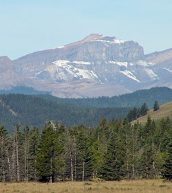
Photo: Castle Rock from Benchlands on Highway #940
Castle Rock
- 2972 m (9,750ft)
51.3678N -115.305W
Located 4 km northwest of Devil's Head
Province: Alberta
Headwater: Bow
Visible from Highway: 940N
Located 4 km northwest of Devil's Head
Province: Alberta
Headwater: Bow
Visible from Highway: 940N
This block-shaped mountain remains officially un-named although it has been referred to as Castle Rock since at least 1886 when it appeared on George Dawson's map. Castle-like in its appearance from the east and north, it is 175 metres higher than nearby Devil's Head.
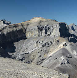
Looking northwest to Castle Rock from Devils Head (courtesy Sonny Bou)