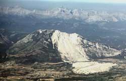
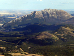
Photo: Looking west-southwest to Turtle Mountain from the air
Turtle Mountain
- 2210 m (7,250ft)
- Naming History
Located in the Crowsnest River Valley north of Drum Creek and east of Lyons Creek
Range: Blairmore
Province: Alberta
Headwater: Oldman
Major Valley: Crowsnest
Visible from Highway: 3, 507
Named by: Louis O. Garnett
Named for: The mountain was said to resemble a turtle although the likeness was lessened by the 1903 rockslide.
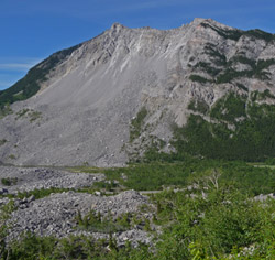
As travellers drive below the summit of Turtle Mountain, just east of Crowsnest Pass, the concepts of erosion and geologic time enter most people's minds. Although our mountain views seem to be something that we will always have, the sight of the Frank Slide provides a reminder that over time these Rocky Mountains will, like other ranges that preceded them in geologic history, eventually disappear. The mountain building process that resulted in the Rockies is known as the Laramide Orogeny and took place between 75 and 55 million years ago. Since that time the mountains that had been uplifted by massive internal forces have been eroded by the combined assaults of glaciation, wind, and water, always augmented by a mountain's relentless foe, the force of gravity. Vast amounts of rock have been removed to be deposited in other locations eventually to become sedimentary rock again, and perhaps in the future, parts of new mountain ranges. The Indians were never comfortable below the mountain and would not camp beside it. They called it "The Mountain that Moves" possibly because of minor rock falls which they had witnessed. The name Turtle was given to the mountain by Louis O. Garnett, an early rancher, because it had the shape of a turtle, including a projecting head. Turtle Mountain is a faulted anticline, the beds of rock rising on its west side, curving over the top, and dipping steeply on the east side. The bedding surfaces between the layers of limestone are zones of weakness as are fractures or joints which cut through the rock at right angles to the bedding surfaces. Water constantly finds its way into the weaker zones, freezes and expands, and makes the cracks larger. In the case of Turtle Mountain, the two zones of weakness (the joint surfaces in the upper part and the bedding surfaces in the lower part) lined up. As well, these steeply dipping rocks were poorly supported by weaker rock below, some of which was being removed by mining. It took millions of years to set the stage but the event was over in seconds. At about 4:10 a.m. on April 29, 1903, part of the eastern summit of Turtle Mountain broke away and slid down the mountain side breaking into fragments, burying the south side of the Town of Frank and the valley to depths of thirty metres or more, and then rushed up the opposite side of the valley to a height of 120 metres. Seventy people were killed by the slide. Although this dramatic event took place almost a century ago the scar and debris look remarkably fresh and provide dramatic evidence of how the erosion of our mountains, generally a process which is the summation of vast numbers of minor events, can be hastened by single massive events. In this case a piece of limestone 425 metres high, 1000 metres wide, and 150 metres thick with a weight estimated to be eighty million tonnes, broke off the mountain. The debris covers about three square kilometres to a depth averaging fourteen metres. Many geologists believe that slides involving units of rock of such massive size do not slide at all. The "Air Cushion Theory" explains why the debris travelled much farther and covered a wider area than would be expected. The theory suggests that the rock rode out over the valley on a layer of trapped, compressed air. In 1904, Turtle Mountain was climbed by none other than Edward Whymper. He visited the Crowsnest Pass area in 1903 and 1904 as part of his efforts to travel in the Canadian Rockies on behalf of the CPR and then to write promotional articles for newspapers and popular journals. Specifically, while in the Crowsnest Pass area, he was to identify suitable locations for the construction of hotels and chalets and also to examine Turtle Mountain. It was hoped that Whymper could determine the possibility of future slides by examining its cracks and fissures. Whymper climbed the mountain, concluding that sooner or later portions of the northwest peak might come down causing damage to the mine entrance and adjacent buildings but that the southeast peak posed no problems because its rock would fall on the centre of the old slide. The mountain appears on George Dawson's 1886 map. For a panoramic view from the summit of Turtle Mountain visit www.canadasmountains.com.
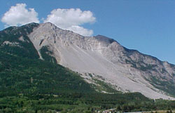
Photo: Looking west-northwest to Turtle Mountain from Highway #3
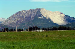
Looking west to Turtle Mountain
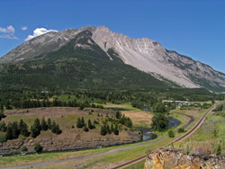
Looking west-northwest to Turtle Mountain
Looking south-southeast to Turtle Mountain from the Interpretive Centre
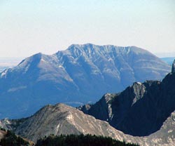
Looking southeast to Turtle Mountain from Mount Erickson (courtesy Sonny Bou)
Looking east-southeast to Turtle Mountain from Phillipps Peak (courtesy Sonny Bou)