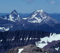
Photo: Looking west-southwest to King Edward Peak (left) and Starvation Peak from Mount Blakiston (courtesy Rienk Lakeman
Starvation Peak
- 2841 m (9,321ft)
- Naming History
Located in the Kashinena Creek Valley, 1.5 km north of King Edward Peak
Province: BC
Headwater: Flathead
Named for: This peak was named after a survey party became lost and ran out of supplies.
Starvation Creek flows from the east, to the south of King Edward Peak and Kishinena Ridge. It is only about one half kilometre north of the international border. Starvation Lake lies at the head of Starvation Creek. The mountain is somewhat removed from the creek and the lake, although a branch of Starvation Creek flows from the northeast from a headwaters between King Edward Peak and Starvation Peak. In his book, "Andy Russell, Memoirs of a Mountain Man," Andy relates how Starvation Valley was named. An International Boundary Survey party had been mapping from the west and planned on meeting another party mapping from the east in the vicinity of where Waterton National Park is now located. When they arrived they couldn't find the other party. Concerned about the Blackfoot Indians, the party decided to spend the winter in a secluded valley where they had noticed plenty of game when they were doing their survey work. Unaware of the fact that the game migrated out of the valley during winter because of the deep snow the men were soon in serious trouble. They survived by eating their horses but were strickened with scurvey. Three of the survey members died and by spring the survivors were in bad shape. When the sap began to flow, they girdled white pine trees with their knives and collected the sap which cured their scurvey. Andy writes of finding, "old, bleached dead pines in that area still showing the knife marks around them -marks that led down to a "V" on the side of the trunk, indicating that somebody many years before had been collecting sap -a reminder of a grim, winter tragedy. [Andy Russell Memoirs of a Mountain Man" page 159, 160] Mount Kirby & Spence is shown to the south of Mount Yarrell on John Palliser's map and on George Dawson's 1886 map. Kirby & Spence were early 19th century British entomologists and the names would likely have been chosen by Thomas Blakiston. [Tony Rees] The names are not in use today but it seems likely that they were applied to the mountains now known as Starvation Peak and King Edward Peak. Dawson's August 15, 1874 journal entry reads, "Looking westward - the valley of the pass is seen to run S.W. between two splendid mountain masses, of which the tops are covered with snow, & which were at once recognisable as Mts Kerby&Spence, and Mt Yarrel of Blackistons map." [Bruce Haig's www.ourheritage.net]