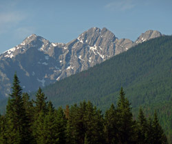
Photo: Looking south to Mount Sinclair from the Kootenay Valley
Mount Sinclair
- 2667 m (8,750ft)
- Naming History
Located in the Kootenay River Valley south of Sinclair Creek; south buttress of Sinclair Pass
Range: Stanford
Province: BC
Park: Kootenay
Headwater: Kootenay/Columbia
Major Valley: Kootenay
Visible from Highway: 93S
Named by: R. Douglas
Named for: Sinclair, James (In 1841 James Sinclair passed below this peak as he led a party of emigrants through the Rockies to the Columbia River.)
In 1841 James Sinclair led a party of emigrants from the Red River Colony in present day Manitoba to Oregon. The journey was instigated by Sir George Simpson, governor of the Hudson Bay Company, in order to reinforce the British presence in the area. The party was made up of 23 Metis families totalling 121 people, including a 75 year old man and babies born during the trip. They travelled first to Fort Edmonton where they left their Red River carts and, guided by the Cree chief Maskepetoon, proceeded on horseback via Lake Minnewanka and a pass between Mount Peechee and Mount Lady Macdonald to the present site of Canmore. They then ascended to White Man Gap between Ha Ling Peak and Mount Rundle, travelled up the Spray valley to White Man Pass, descended the Cross River to the Kootenay River from which they crossed Sinclair Pass (below Sinclair Peak) to the Columbia and eventually reached Oregon. In 1854, Sinclair, again guided by Maskepetoon, led a party to Oregon from Red River, this time a group of about one hundred driving 250 head of cattle. After receiving reports of a shorter route, they travelled up the Kananaskis River and are thought to have crossed North Kananaskis Pass, a remarkable accomplishment. Sadly, Sinclair was shot and killed in 1856 when Indians attacked an American post on the Columbia River that he happened to be visiting.
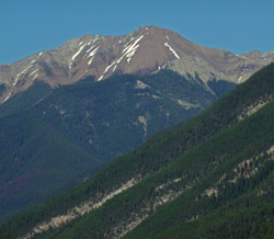
Photo: Looking east across the Columbia Valley to Mount Sinclair
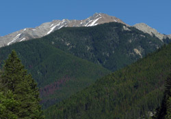
Photo: Looking east up Sinclair Creek to Mount Sinclair