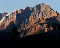
Photo: Looking southwest to Mount Hurd from the Emerald Lake Road
Mount Hurd
- 2993 m (9,820ft)
- First Ascent
- Naming History
51.2839N -116.534W
Located in the Kicking Horse River Valley at the head of Frenchman Creek; northwest buttress of Hurd Pass
Range: Ottertail
Province: BC
Park: Yoho
Headwater: Columbia
Major Valley: Kicking Horse
Visible from Highway: 1
Located in the Kicking Horse River Valley at the head of Frenchman Creek; northwest buttress of Hurd Pass
Range: Ottertail
Province: BC
Park: Yoho
Headwater: Columbia
Major Valley: Kicking Horse
Visible from Highway: 1
Ascent Date: 1948
Ascent Party: Mr. and Mrs. E. Cromwell
Ascent Party: Mr. and Mrs. E. Cromwell
Year Named: 1904
Named by: Tom Wilson
Named for: Hurd, Major M.F. (A CPR survey engineer, Major Hurd was an assistant to Major Rogers during the survey of this area of the route.)
Named by: Tom Wilson
Named for: Hurd, Major M.F. (A CPR survey engineer, Major Hurd was an assistant to Major Rogers during the survey of this area of the route.)
Mount Hurd was featured on a ten-cent stamp, issued in 1928 and taken from a painting by the Canadian landscape artist, Frederic Marlett Bell-Smith who was a regular visitor to the Rockies. [Boles et al]
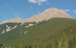
Photo: Mount Hurd from the southwest on Highway #1, 7 km north of Kicking Horse River Bridge
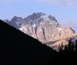
Looking south to Mount Hurd from the Trans-Canada Highway southwest of Field
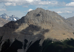
Looking east to Mount Hurd from Mount Hunter (courtesy Sonny Bou)