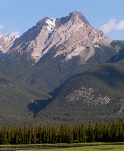
Photo: Looking northwest to Gargoyle Mountain from two km northeast of the Athabasca River Bridge on Highway #16
Gargoyle Mountain
- 2693 m (8,836ft)
- Naming History
53.1017N -118.157W
Located in the Athabasca River Valley, west of Vine Creek and north of Corral Creek; south end of Grassy Ridge
Province: Alberta
Park: Jasper
Headwater: Athabasca
Visible from Highway: 16
Located in the Athabasca River Valley, west of Vine Creek and north of Corral Creek; south end of Grassy Ridge
Province: Alberta
Park: Jasper
Headwater: Athabasca
Visible from Highway: 16
Year Named: 1916
Named by: Morrison Bridgland
Named for: Rock formations around a stream which flows from its base were thought to resemble gargoyles, waterspouts generally in the form of a human or creature of some kind which were often incorporated into the decorative architecture of buildings.
Named by: Morrison Bridgland
Named for: Rock formations around a stream which flows from its base were thought to resemble gargoyles, waterspouts generally in the form of a human or creature of some kind which were often incorporated into the decorative architecture of buildings.
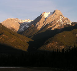
Photo: Looking northwest to Gargoyle Mountain from Highway #16