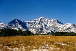
Looking east to Spread Eagle Mountain (the eastern end of Spionkop Ridge)
Spread Eagle Mountain
- 2484 m (8,150ft)
Located south of Spionkop Creek and north of Yarrow Creek; the eastern end of Spionkop Ridge
Province: Alberta
Headwater: Oldman
This peak that forms the eastern end of Spionkop Ridge is very prominent from Highway #6, in the Twin Butte area. What is now locally referred to as Spread Eagle Mountain was known a Mount Roche for a period of time. The name was suggested in 1917 for Lieutenant Richard Roche of the Royal Navy who had been a member of the British Boundary Commission party, which surveyed the international boundary from the Pacific to the Rockies in the late 1850s. The name was listed in Place Names of Alberta 1928, but never officially approved. It is likely that the name was a suggestion of the Interprovincial Boundary Commission.
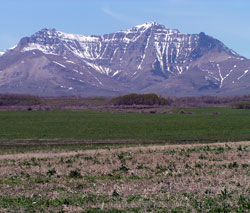
Looking east to Spread Eagle Mountain (the eastern end of Spionkop Ridge)