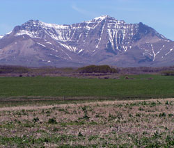
Photo: Looking west to the east end of Spionkop Ridge (Spread Eagle Mountain)
Spionkop Ridge
- 2576 m (8,453ft)
Located in the Castle River Valley, this 8 km long ridge separates Spionkop Creek from Yarrow Creek
Province: Alberta
Headwater: Oldman
Visible from Highway: 6
Spionkop Ridge is seven kilometres in length and trends WSW-ENE. Its high point of 2576 metres lies at its western end but it is the eastern end (2444 metres) which we see rising only 13 kilometres from Twin Butte. Its profile is very similar to that of Mount Burke, a peak in the northern part of the Livingstone Range which lies at the headwaters of Pekisko Creek, west of Nanton. The original Spion Kop is a mountain in southern Africa. A battle in the South African (Boer) War (1899-1902) was fought on this mountain and it is unusual to find an Alberta mountain with a name related to this war. The word "kop" in the Afrikaans language means "small mountain." The east end of Spionkop Ridge is now locally referred to as Spread Eagle Mountain was known as Mount Roche for a period of time. The name was suggested in 1917 for Lieutenant Richard Roche of the Royal Navy who had been a member of the British Boundary Commission party, which surveyed the international boundary from the Pacific to the Rockies in the late 1850s. The name was listed in Place Names of Alberta 1928, but never officially approved. It is likely that the name was a suggestion of the Interprovincial Boundary Commission. [Aubrey] SPION KOP MOUNTAIN; January 24th, 1900 "I have done all I can, and I am not going back," replied Colonel Thorneycroft to Winston Churchill who had delivered an order from Thorneycroft's superior. The colonel was on his way down the mountain and met Churchill who was on his way up. The 26 year old future prime minister of Great Britain and the man who was to lead the Free World in its great war against Nazi Germany four decades later had just delivered General Warren's directive that the British position on top of the mountain was to be held. But the General's headquarters were in a valley two miles west of Spion Kop. He could observe nothing and had to rely on messengers to bring him reports so he was not aware of the day's action. Colonel Thorneycroft and 4500 British troops had just spent a very full day on the mountain. The Boers were white residents of Dutch, German, and Huguenot descent who had formed the South African Republic and the Orange Free State. They resented the fact that the British had gradually laid claim to south African lands and taken control of its mining operations and commerce. After declaring war on Britain and winning some intitial victories, they were eventually overwhelmed by the reinforced British in what became known as the South African or Boer War (1899-1902). Some 8000 Canadians, almost all cavalrymen, sailed to South Africa to support the Mother Country and 244 did not return, the majority dying of disease. The troops distinguished themselves and Canadians at home viewed their soldier's success with pride and marked their victories by massive parades and demonstrations. Spion Kop is a three-cornered, table-mountain near the headwaters of the Orange River in southeastern Africa. and it dominated the area in which the Boers and the British were fighting. At 9:00 pm on January 23, 1900 Colonel Thorneycroft led his force of 1700 men up the southern side of the peak, reaching the top seven hours later. The soldiers immediately tried to dig themselves in but their tools were almost useless against the solid rock. When the mists lifted at 8:00 am the British found that the shallow trench they had so laboriously scraped out was in the centre of an exposed plateau. It became a lovely clear day and well-placed Boer marksmen began to fire upon the huddled British troops with rifles, heavy guns, and two pom-poms causing heavy casualties. At about 1:00 pm the strain proved too much and some soldiers surrendered and a more complete collapse was only prevented by the personal intervention of Thorneycroft who rallied the faint-hearted, and the bitter struggle was resumed. During the afternoon reinforcements arrived and almost 2500 troops were packed on the summit while another 2000 waited just below. As darkness arrived, a steady trickle of men began to abandon the position and at 8:00 pm Thorneycroft ordered the abandonment of the mountain. As the day wore on the Boers became disheartened as well, and many deserted. At nightfall they too retreated. When the Boers re-occupied the summit the next day they were horrified because, "There cannot have been many battlefields where there was such an accumulation of horrors within so small a compass." The British had suffered 350 killed and the Boers about 300. No Canadian units were involved in the battle and one wonders who it was whose view of this mountain brought back to mind these horrors from the South African War.
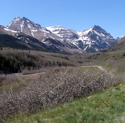
Photo: Looking west up Spionkop Valley with Spionkop Ridge at left
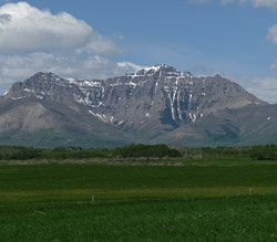
Looking west to the east end of Spiokop Ridge (Spread Eagle Mountain) from Highway #6
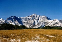
Looking west to Spionkop Ridge