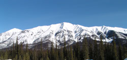
Photo: Mount Shanks (left) and Hawk Ridge from Highway #93(S) in the Kootenay River Valley near the Simpson River
Mount Shanks
- 2844 m (9,331ft)
- Naming History
51.0042N -115.631W
Located in the Vermillion River Valley at the southeast end of Hawk Ridge; southwest of Verdant Creek; north of the Simpson River
Province: BC
Park: Assiniboine/Kootenay
Headwater: Kootenay
Located in the Vermillion River Valley at the southeast end of Hawk Ridge; southwest of Verdant Creek; north of the Simpson River
Province: BC
Park: Assiniboine/Kootenay
Headwater: Kootenay
Year Named: 1927
Named for: Shanks, Thomas (A surveyor, Thomas Shanks was assistant Director General of the Topographical Survey of Canada.)
Named for: Shanks, Thomas (A surveyor, Thomas Shanks was assistant Director General of the Topographical Survey of Canada.)