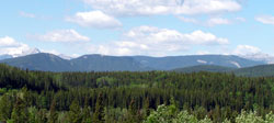
Photo: Powderface Ridge from the northeast on Highway #66 at Camp Horizons
Powderface Ridge
- 2210 m (7,250ft)
- Naming History
50.8436N -114.849W
Located in the Elbow River Valley east of Ford Creek; opposite Forgetmenot Ridge
Province: Alberta
Park: Kananaskis
Headwater: Bow
Major Valley: Elbow
Visible from Highway: 66
Located in the Elbow River Valley east of Ford Creek; opposite Forgetmenot Ridge
Province: Alberta
Park: Kananaskis
Headwater: Bow
Major Valley: Elbow
Visible from Highway: 66
Year Named: 1949
Named for: Powderface, Tom (A Stoney Indian, Tom Powderface lived in the Bragg Creek area.)
Named for: Powderface, Tom (A Stoney Indian, Tom Powderface lived in the Bragg Creek area.)
This eight kilometre long, grass and tree covered ridge stretches from Prairie Creek in the north to the Elbow River to the west of the Powderface Ridge Trail. *A hiking route to the summit is described in Gillean Daffern's Kananaskis Country Trail Guide.
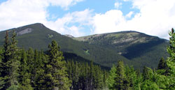
Photo: The southern end of Powderface Ridge from the south on Highway #66 at Little Elbow Campground