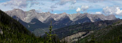
Photo: Looking west from North Fork Pass to the Wisukitsak Range (courtesy Allan Schierman)
North Fork Pass (Oldman)
- 1996 m (6550ft)
- Naming History
- Peaks and Rivers
Province: Alberta/BC
Park:
Named by: George Dawson
Named for: The pass is located above the Dutch Creek Valley. Dutch Creek was formerly known as the North Fork of the Oldman River.
Mountain (SE): Mount Erris
Headwaters (NE): Dutch Creek
Headwaters (SW): South Line Creek
NORTH FORK PASS (Oldman)
Another North Fork Pass lies in the upper Cascade River area in Banff National Park.
Regarding North Fork Pass, Part I of the Interprovincial Boudary Survey Report (1917) reads as follows: "The North Fork Pass was traversed in 1884 by the late Dr. George Dawson, C.M.G., Director of the Geological Survey of Canada, and the name was given to it by him; so far is as known, it had not previously been crossed except by Indians. The name is due to its providing a feasible line of travel across the Main Range from Elk River Valley to the valley of the stream shown as the "North Fork Old Man River" on Dawson's Map of a protion of the Rocky Mountians, published by the Geological Surey in1886. The term "North Fork" was appied by him to distinguish this branch of "Old Man River" from the "South Fork" of the same stream, which heads on the east side of the watershed not very far north of South Kootenay Pass and joins the "North Fork" a few miles northwest of Pincher Station on the Canadian Pacific Railway. The name "South Fork Old Man River" was subsequently changed to Southfork River and again, quite recently, to Castle River. For the northern branch, the term "North Fork" has been dropped an it is now known as Oldman River."