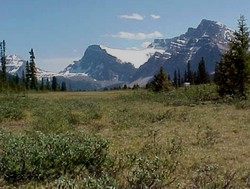
Photo: Looking south from the summit of Bow Pass
Bow Pass
- 2069 m (6787ft)
- Naming History
- Peaks and Rivers
Province: Alberta
Park: Banff
Named by:
Named for: The pass takes its name from the Bow River whose headwaters flow to southeast from the pass.
Mountain (SE): Observation Peak
Headwaters (NE): Mistaya River
Headwaters (SW): Bow River
BOW PASS
Highway #93 travels over this pass, the highest road in Canadas national parks. Its northern slopes are made up of a gently sloping wedge of meadow with clumps of low bushes and trees.
Upon reaching this important divide it is still well worth the time to pull over and enjoy the distant peaks, including Sunwapta PeakWalter Wilcox travelled over Bow Pass in 1896. In his book, "The Canadian Rockies," he describes the pass as follows: "Open, treeless moors, abounding in irregular mounds and depressions, covered with a scant growth of grass, stunted willows, and a dwarfed underbrush, extended in a gradually rising valley to a pass about three miles north-west of the lake (Bow Lake). The view on the other side of the pass is one of the most inspiring in the mountains. The slope drops suddenly a thousand feet and discloses the entire length of Bear (Mistaya) Creek Valley, or the Little Fork of the Saskatchewan."