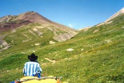
Photo: Approaching Pipestone Pass from the southeast (The lowest point is left of the knob.)
Pipestone Pass
- 2420 m (7940ft)
- Naming History
- Peaks and Rivers
Province: Alberta
Park: Banff
Named by:
Named for: The pass takes its name from the Pipestone River in which red and green soft shales may be found. These were carved by the natives to make pipes.
Mountain (SE): Devon Mountain
Headwaters (NE): Pipestone River
Headwaters (SW): Sifleur River
Although the actual elevation of Pipestone Pass is 2420 m (7940'), the trail over the passe reaches a height of 2480 m (8137') as it travels to the northeast of an isolated high area on the summit of the pass.
With this elevation and its geographic significance, Pipestone Pass is one of the classic passes in the Canadian Rockies. Another feature of this high area is the nearby Clearwater Pass, the Clearwater River descending to the east to form one of the major valleys to cut through the various ranges to the foothills. So three major rivers descend from this _culmination.î
This historic route is the highpoint at the head of the Siffleur River and the Pipestone River. It is the most direct route from the Bow Valley in the vicinity of Lake Louise to the Saskatchewan River Valley to the north. It features expansive areas of high elevation alpine meadows on both sides of the high point.
The pass was traversed by James Hector on 27 August, 1859. His journal describes the trip as follows: After camping to the south of the pass, _Ûopposite to a waterfall which forms the source of Pipe Stone Creek, and where the stream leaps and rushes down a gutter-like channel, from a height of 450 feet,î they set out to, _ascend to the height of land by a steep rocky path that led at some places close by snow that was still lying from last winter. After five miles we got above the woods, and passed over a fine sloping prairie, with big bald mountains on either side. Plants with esculent roots were very abundant here, and many parts of the sward looked as if it had been ploughed, where the bears had been rooting them up like pigsÛ.Two miles further we passed over a bleak bare _divide,î where there was no vegetation, and elevated about 2000 feet above last nights encampment.î
The pass remains just as described by Hector and the bears still make a portion of the approach from the south appear to be plowed.
In mid-September of the same year, James Carnegie (Earl of Southesk) rode through the pass in the opposite direction through snow and mist with, _only enough of the surrounding rocks and mountains visible Ûto show how much noble scenery was being lost to me forever.î
It is truly remarkable that the two Scots, James Hector and James Carnegie, almost met each other on the trip over Pipestone Pass at a time when they were two of the very few Europeans travelling in the Canadian Rockies. Hector later wrote, that it was quite the coincidence that, "the only two travellers, excepting Indians and a few employees of the fur companies, that have ever been in this district of the mountains, should have so nearly met, and without the least knowledge of each other's proximity."
In 1898 Norman Collie, Hugh Stutfield and Herman Woolley traversed the pass on their way to explore in the headwaters of the Saskatchewan River.
Tom Wilson completed a legendary crossing of Pipestone Pass. After selling his outfitting business, Tom continued to live in Banff but spent most of his time raising horses in the Kootenay Plains, a unique area of prairie like grassland in the valley of the North Saskatchewan River downstream from Mount Wilson. During the early winter of 1904, Tom was at his horse ranch and as Christmas Day approached he decided to join his family in Banff for dinner. Despite the fact that conditions were not favourable, he set off travelling up the Siffleur River to cross Pipestone Pass and descend the Pipestone River to Lake Louise. Arthur Wheeler described the trip as involving, "a snowshoe tramp alone of seventy miles through lonely tree-clad valleys, through rock-bound gorges and over wind-swept passes, where all nature lay stark and stiff in the icy grip of winter." At one point he fell through a snowbridge during a fierce windstorm and had great difficulty drying his wet socks and moccasins. "It was drifting and snowing so hard that the snow covered my sox and moccasins as fast as I could wring them dry, and, owing to the fierce wind, the flames leaped in every direction, making it impossible to get near the fire, so at half past nine I gave it up, put on my wet footgear and snowshoes and started down the valley. I could not see and felt the way with a stick... It kept the circulation going." When daylight came he was in heavy timber and was able to dry his footgear. The last three days of his journey were made without food. Tom wrote, "...the last day I could only make about fifty yards without resting, and my back tracks did not leave a very straight line. The chief trouble I had was to keep from going to sleep; it would have been so much easier to quit than to go on."