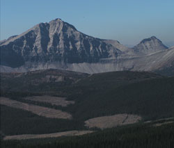
Photo: Looking west to the 9450 foot peak on the continental divide, with the lower peak labelled as Mount O'Rourke beyond at right
Mount O'Rourke
- 2880 m (9,450ft)
- Naming History
Located on the continental divide at the headwaters of Kilmarnock Creeks, the headwaters of Lost Creek and the head of Chauncey Creek
Range: High Rock
Province: Alberta/BC
Headwater: Kootenay
Named for: O'Rourke, Private Michael Joseph VC (Pte. O'Rourke was a stretcher bearer with the Canadian Expeditionary Force during WW I. He was awarded the Victoria Cross in 1917 after worked unceasingly for three days and nights while constantly under fire.)
During the period 15/17 August 1917 at Hill 60 near Lens, France, Private O'Rourke of the British Columbia Regiment, who was a stretcher-bearer, worked unceasingly for three days and nights bringing in the wounded, dressing their wounds and getting them food and water. During the whole of this period the area in which he worked was swept by heavy machine-gun and rifle fire and on several occasions he was knocked down and partially buried by enemy shells. His courage and devotion in carrying out his rescue work in spite of exhaustion and incessant heavy fire inspired all ranks and undoubtedly saved many lives. 82J/02 and the original Boundary Survey Atlas shows this peak to be a minor outlier (8550') to a much higher (9450') peak located on the Continental Divide, 1.6 km to the southeast. One wonders why the peak name is attached to the minor outlier. Perhaps the name was applied to the wrong location on the Boundary Survey Map and subsequent maps have been based on the original. Maybe it has never been placed where it was originally meant to be. The area is at a point where two of the map sheets join and this may have contributed to an error being made. The location and elevation of Mount O'Rourke (as seen above) are for the point on the continental divide. The following is a comment by Rienk Lakeman received on September 26, 2001: "I've had a chance to get to the summit (of the 9450' peak), where all I found was a cairn and a small register (film container) placed by an Allan Schierman on Aug. 24th 1997 which diplomatically names the peak 'unnamed 9400'. The official O'Rourke is physically dwarfed by everything around it and although I didn't get up to its summit I could see a wooden stick, probably a branch, protruding from a pile of rocks on the summit. I approached the cirque from the east side of the divide, and the smaller peak is really best approached from the west along Kilmarnock creek. This looks like industrial hiking at its worst, frankly the coal mines to the west make the place look like hell, so I'm not very inclined to go up to the official peak just to check it out. The main peak is very impressive, and I've no doubt that in the first quarter of the last century there was a permanent snow field just below the west summit on the north face, which was the route I used. It seems very likely to me after being there and seeing this unnamed peak in relation to Pierce and Farquhar that the maps are in error." Gillean Daffern feels that Arthur Wheeler and the Interprovincial Boundary Commission didn't make mistakes like this and that they must have had a reason for doing what they did.