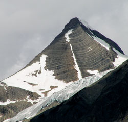
Photo: Looking north-northwest to the southern outlier of Mount Barlow from the Mummery Creek Bridge on the Blaeberry River Road
Mount Barlow
- 3120 m (10,237ft)
- First Ascent
- Naming History
51.7053N -116.810W
Located on the continental divide at the southern edge of the Freshfield Icefield
Province: Alberta/BC
Park: Banff
Headwater: Saskatchewan/Columbia
Located on the continental divide at the southern edge of the Freshfield Icefield
Province: Alberta/BC
Park: Banff
Headwater: Saskatchewan/Columbia
Ascent Date: 1930
Ascent Party: E. Cromwell, J. Monroe Thorington
Ascent Guide: Peter Kaufmann
Ascent Party: E. Cromwell, J. Monroe Thorington
Ascent Guide: Peter Kaufmann
Year Named: 1916
Named by: D.B. Dowling (Dr. Dowling was an engineer in the Geological Survey of Canada)
Named for: Barlow, Dr. Alfred Ernest (A member of the Geological Survey of Canada and consulting geologist who, with his wife, drowned in the Empress of Ireland disaster in the St. Lawrence River in 1914)
Named by: D.B. Dowling (Dr. Dowling was an engineer in the Geological Survey of Canada)
Named for: Barlow, Dr. Alfred Ernest (A member of the Geological Survey of Canada and consulting geologist who, with his wife, drowned in the Empress of Ireland disaster in the St. Lawrence River in 1914)
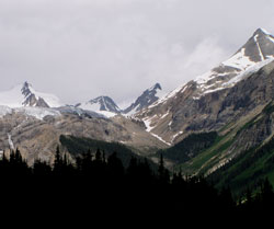
Photo: (l-r) Jones Peak, Mount Gilgit, Mount Helmer, and Mount Barlow outlier from the Mummery Creek Bridge on the Blaeberry River Road