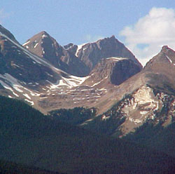
Photo: Looking north to an un-named peak and Mount Marpole (in distance at right) beyond "Top Hat"; Emerald Peak at right
Mount Marpole
- 2997 m (9,833ft)
- First Ascent
- Naming History
- Hiking and Trails
51.4925N -116.580W
Located in the Kiwetinok River Valley; western buttress of Emerald Pass; 1.5 km southwest of The President
Province: BC
Park: Yoho
Headwater: Columbia
Visible from Highway: 1
Located in the Kiwetinok River Valley; western buttress of Emerald Pass; 1.5 km southwest of The President
Province: BC
Park: Yoho
Headwater: Columbia
Visible from Highway: 1
Ascent Date: 1901
Ascent Party: Edward Whymper
Ascent Guide: J. Bossonay, C. Kaufmann, C. Klucker, J. Pollinger
Ascent Party: Edward Whymper
Ascent Guide: J. Bossonay, C. Kaufmann, C. Klucker, J. Pollinger
Year Named: 1901
Named by: Edward Whymper
Named for: Marpole, Richard (Richard Marpole was General Executive Assistant of the Pacific Division of the CPR when this mountain was named in his honour.)
Named by: Edward Whymper
Named for: Marpole, Richard (Richard Marpole was General Executive Assistant of the Pacific Division of the CPR when this mountain was named in his honour.)
Popular Hike: Emerald Lake/Yoho Valley
This peak lies to the southwest of The President, across Emerald Pass.
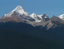
Photo: Looking north to (l-r) Mount Carnarvon, un-named, Mount Marpole (beyond), and Emerld Peak