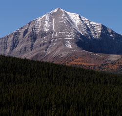
Photo: Looking west to Mount Lyall from the Oldman River Valley
Mount Lyall
- 2950 m (9,682ft)
- Naming History
Located on the continental divide in the Oldman River Valley at the headwaters of Lyall Creek
Range: High Rock
Province: Alberta/BC
Headwater: Oldman/Kootenay
Major Valley: Oldman
Named for: Lyall, David (Dr. Lyall was the surgeon attached to the British Boundary Commission of 1858-1862 which mapped the border between the Pacific and the Rockies.
Dr. David Lyall was a surgeon with the British Boundary Commission which mapped the border with the United States from the Rockies to the Pacific during the years 1858-1862. Since the mountain lies some distance from the border, it is likely it was named to honour his work as a naturalist with a particular interest in alpine plants rather than his contribution to the mapping of the international border. During his time in Canada Lyall sent some 1,375 species of plants back to the Royal Botanical Gardens at Kew, England,. Some he chose to name after himself, the most well known of which is the Alpine or Lyall's Larch which almost defines the alpine zone in the southern Alberta Rockies south of the Bow Valley. This tree grows between 1900 and 2100 metres and has light green, soft needles which turn a beautiful golden colour in fall and are shed. Another plant Dr. Lyall chose to name after himself is Lyall's Saxifrage. Often growing in dense masses in wet moss beside alpine brooks, the small delicate flowers are white with yellow spots.
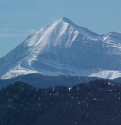
Photo: Looking southwest to Mount Lyall from Mount Burke
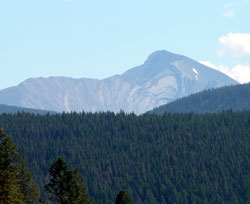
Looking southeast to Mount Lyall from the Elk Valley
Looking southeast to Mount Lyall from the Elk Valley (courtesy Katy Drijber)