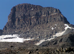
Photo: Looking southwest to the summit block of Mount Kerr from the upper Little Yoho Valley
Mount Kerr (BC)
- 2863 m (9,394ft)
- First Ascent
- Naming History
- Hiking and Trails
51.5050N -116.594W
Located at the head of the Little Yoho River and Kiwetinok Creek; Mount Kerr's northern outlier forms the south buttress of Kiwetinok Pass
Province: BC
Park: Yoho
Headwater: Columbia
Located at the head of the Little Yoho River and Kiwetinok Creek; Mount Kerr's northern outlier forms the south buttress of Kiwetinok Pass
Province: BC
Park: Yoho
Headwater: Columbia
Ascent Date: 1901
Ascent Party: Edward Whymper
Ascent Guide: J. Bossoney, C. Kaufmann, C. Klucker, J. Pollinger
Ascent Party: Edward Whymper
Ascent Guide: J. Bossoney, C. Kaufmann, C. Klucker, J. Pollinger
Year Named: 1907
Named by: Edward Whymper
Named for: Kerr, Robert (Passenger Traffic Manger for the CPR, Robert Kerr played a major role in arranging for the visits of Edmund Whymper to the Canadian Rockies.)
Named by: Edward Whymper
Named for: Kerr, Robert (Passenger Traffic Manger for the CPR, Robert Kerr played a major role in arranging for the visits of Edmund Whymper to the Canadian Rockies.)
Popular Hike: Emerald Lake/Yoho Valley
Mount Kerr is marked incorrectly on the NTS topo map and on the Map Town Publishing Lake Louise/Yoho map. The peak is the high point at 282058. Mount Kerr is a very prominent little mountain from the upper Little Yoho valley and the Stanley Mitchell ACC hut. Please note that there is another Mount Kerr in the Canadian Rockies in Jasper National Park.
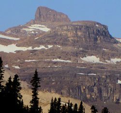
Photo: Mount Kerr from the Little Yoho Valley
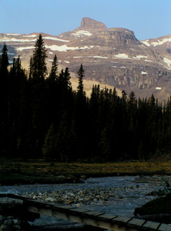
Looking west to Mount Kerr at the head of the Little Yoho Valley