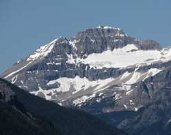
Photo: Isabelle Peak from the southwest on Highway #93(S)
Isabelle Peak
- 2926 m (9,600ft)
- First Ascent
- Naming History
51.1261N -116.009W
Located on the continental divide in the Vermilion River Valley north of Hawk Creek; southern end of the Ball Range
Range: Ball
Province: Alberta/BC
Park: Banff/Kootenay
Headwater: Bow/Kootenay
Major Valley: Vermilion
Visible from Highway: 1, 93S
Located on the continental divide in the Vermilion River Valley north of Hawk Creek; southern end of the Ball Range
Range: Ball
Province: Alberta/BC
Park: Banff/Kootenay
Headwater: Bow/Kootenay
Major Valley: Vermilion
Visible from Highway: 1, 93S
Ascent Date: 1913
Ascent Party: Interprovincial Boundary Commission
Ascent Party: Interprovincial Boundary Commission
Year Named: 1906
Named by: Charles Thompson
Named for: Thompson, Isabelle (Isabelle was Charles Thompson''s sister. Charles Thompson was a prominent early mountaineer in the Canadian Rockies.) (See Charles Thompson''s biography)
Named by: Charles Thompson
Named for: Thompson, Isabelle (Isabelle was Charles Thompson''s sister. Charles Thompson was a prominent early mountaineer in the Canadian Rockies.) (See Charles Thompson''s biography)
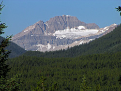
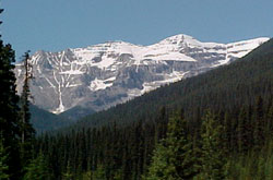
Photo: Looking southwest up Redearth Creek Valley to Isabelle Peak from the Bow Valley Parkway
Looking southwest to Isabelle Peak from Mount Ishbel (courtesy Sonny Bou)