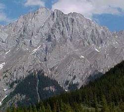
Photo: Mount Hood from Hood Creek on Highway 40
Mount Hood
- 2903 m (9,525ft)
- First Ascent
- Naming History
50.7469N -115.089W
Located between the Kananaskis Valley and the headwaters of Evan Thomas Creek; head of Hood Creek
Range: Opal
Province: Alberta
Park: Kananaskis
Headwater: Bow
Visible from Highway: 40S, 742
Located between the Kananaskis Valley and the headwaters of Evan Thomas Creek; head of Hood Creek
Range: Opal
Province: Alberta
Park: Kananaskis
Headwater: Bow
Visible from Highway: 40S, 742
Ascent Date: 1953
Ascent Party: J. Dodds, W. Lemmon, and party
Ascent Party: J. Dodds, W. Lemmon, and party
Year Named: 1922
Named for: Hood, Hon. Horace (Rear Admiral Hood participated in the Battle of Jutland during WW I. He went down with HMS Invincible. Mount Invincible is part of the Kananaskis Range and lies across the valley from Mount Hood.)
Named for: Hood, Hon. Horace (Rear Admiral Hood participated in the Battle of Jutland during WW I. He went down with HMS Invincible. Mount Invincible is part of the Kananaskis Range and lies across the valley from Mount Hood.)
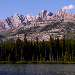
Photo: (l-r) Mount Evan-Thomas, Mount Packenham, and Mount Hood from the Smith-Dorrien Road near Lower Kananaskis Lake
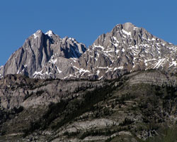
Looking north-northeast to Mount Packenham (left) and Mount Hood from the Smith-Dorrien Road