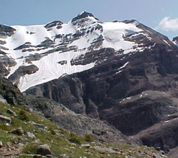
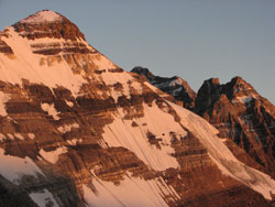
Photo: Looking south to Glacier Peak from the lower slopes of Mount Huber
Glacier Peak
- 3283 m (10,772ft)
- First Ascent
- Naming History
- Hiking and Trails
51.3506N -116.284W
Located between Lake Oesa and Paradise Creek and between Ringrose Peak and Mount Lefroy
Province: Alberta
Park: Banff
Headwater: Bow
Visible from Highway: 1
Located between Lake Oesa and Paradise Creek and between Ringrose Peak and Mount Lefroy
Province: Alberta
Park: Banff
Headwater: Bow
Visible from Highway: 1
Ascent Date: 1909
Ascent Party: V.A. Fynn, A.R. Hart, C.A. Richardson
Ascent Guide: L.C. Wilson
Ascent Party: V.A. Fynn, A.R. Hart, C.A. Richardson
Ascent Guide: L.C. Wilson
Year Named: 1894
Named by: Samuel E.S. Allen
Named for: Allen noted the glacier on the northern slopes of the mountain.
Named by: Samuel E.S. Allen
Named for: Allen noted the glacier on the northern slopes of the mountain.
Popular Hike: Lakes Louise/Moraine/O'Hara
Journal Reference: AJ 25-85, CAJ 2-84
Journal Reference: AJ 25-85, CAJ 2-84
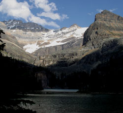
Photo: Looking west across Lake OHara to (l-r) Mount Lefroy, Glacier Peak, and Mount Yukness (courtesy Rob and Kathy Taerum)
Looking southwest up Paradise Creek and beyond Mount Lefroy to Glacier Peak (left) from Morant Curve on the Bow Valley Parkway
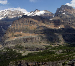
Looking east-northeast across Opabin Valley and beyond Mount Yukness to (l-r) Mount Lefroy, Glacier Peak, and Ringrose Peak (courtesy Kathy and Rob Taerum)
Looking south to Glacier Peak from the southeast ridge of Mount Victoria (courtesy Geoff Lampard)
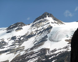
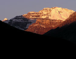
Looking west to Glacier Peak