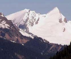
Photo: Arete Peak (left) and Mount Des Poilus from the Trans-Canada Highway near the Spiral Tunnels Viewpoint
Arete Peak
- 3063 m (10,050ft)
- Naming History
- Hiking and Trails
51.5875N -116.604W
Located in the Amiskwi River Valley 0.7 km south of Mount des Poilus; north and east of Glacier des Poilus
Province: BC
Park: Yoho
Headwater: Columbia
Visible from Highway: 1
Located in the Amiskwi River Valley 0.7 km south of Mount des Poilus; north and east of Glacier des Poilus
Province: BC
Park: Yoho
Headwater: Columbia
Visible from Highway: 1
Year Named: 1915
Named for: An arete is a narrow ridge with steep slopes on both sides. The Interprovincial Boundary Commission assigned this name probably because they were impressed with the arete which connects the mountain with Mount Des Poilus
Named for: An arete is a narrow ridge with steep slopes on both sides. The Interprovincial Boundary Commission assigned this name probably because they were impressed with the arete which connects the mountain with Mount Des Poilus
Popular Hike: Emerald Lake/Yoho Valley
Please note that there is an Arete Mountain in Jasper National Park.
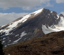
Photo: Looking northwest to Arete Peak from Waterfall Valley (courtesy Rob and Kathy Taerum)
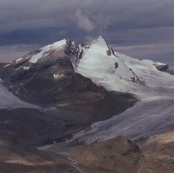
Looking north-northeast to Arete Peak (left) and Mount Des Poilus from Whaleback Ridge