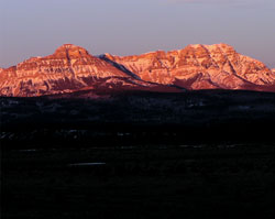
Photo: Association Peak (left) and End Mountain from the Trans-Canada Highway
End Mountain
- 2453 m (8,050ft)
- Naming History
Located south of South Ghost River
Province: Alberta
Headwater: Bow
Visible from Highway: 1
Named by: J.J. McArthur (probably)
Named for: The peak is at the northern end of a small range which lies in front of the main front range.
To the north of Mount John Laurie lies a small, two mountain range located five km east of the main front range between the headwaters of Old Fort Creek and the South Ghost River. End Mountain is the northernmost and higher of the two. Not a spectacular peak, it must have been of some significance to early travellers in the area because it was named as early as 1884, presumably because it forms the northern end of the small range. Note that the 1:250,000 topo map (82O) shows End Mountain as a high point on a ridge 2.7 km directly west of the feature named End Mountain on the 1:50,000 as described above. This is thought to be an error on the 1:250,000.
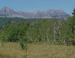
Photo: Association Peak (left) and End Mountain from Highway #1A, just east of Old Fort Creek