
Photo: Ebon Peak from north of Silverhorn Creek on the Icefields Parkway
Ebon Peak
- 2910 m (9,548ft)
- First Ascent
- Naming History
51.7775N -116.647W
Located on the continental divide in the Mistaya River Blaeberry River Valleys at the head of Ebon Creek; south of Aries Peak; north of Breaker Mountain
Province: Alberta/BC
Park: Banff
Headwater: Saskatchewan/Columbia
Major Valley: Mistaya
Visible from Highway: 93N
Located on the continental divide in the Mistaya River Blaeberry River Valleys at the head of Ebon Creek; south of Aries Peak; north of Breaker Mountain
Province: Alberta/BC
Park: Banff
Headwater: Saskatchewan/Columbia
Major Valley: Mistaya
Visible from Highway: 93N
Ascent Date: 1972
Ascent Party: D. Forest, S. King, J. Pomeroy, G. Schlee, M. Toft
Ascent Party: D. Forest, S. King, J. Pomeroy, G. Schlee, M. Toft
Year Named: 1917
Named by: Arthur Wheeler
Named for: Ebony-coloured (almost black) Ordivician rock makes up the summit of the mountain.
Named by: Arthur Wheeler
Named for: Ebony-coloured (almost black) Ordivician rock makes up the summit of the mountain.
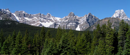
Photo: (l-r) Ebon Peak, Aries Peak, Stairway Peak, Midway Peak, Mount Synge, and Howse Peak from the east on the Icefields Parkway