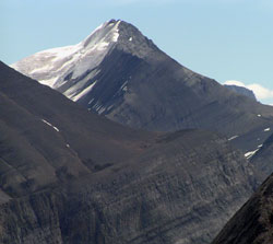
Photo: Looking southeast to Mount Coleman from Parker Ridge
Mount Coleman
- 3135 m (10,286ft)
- Naming History
Located in the North Saskatchewan River Valley west of Sunset Pass and south of Huntington Creek
Province: Alberta
Park: Banff
Headwater: Saskatchewan
Major Valley: Saskatchewan
Visible from Highway: 93N
Named for: Coleman, Dr. Arthur P. (A geologist, Dr. Coleman was one of the first to explore the area that is now Jasper National Park.) (see biog.)
Mount Coleman is a "helmet shaped" peak which may be seen on the east side of the Icefields Parkway, to the north of Saskatchewan River Crossing. Arthur Coleman (1852-1939) was a Professor of Geology at the University of Toronto who travelled widely in the Canadian Rockies and Selkirks. He completed a total of eight trips major trips, all of which were exploratory in nature. His brother, L. Quincy Coleman lived in Morley and was Arthur's outfitter for his last five expeditions in the Rockies. Coleman first visited the mountains of western Canada in 1884, reaching the end of the railway at Laggan (Lake Louise). He carried on to Golden and visited the Selkirks. While travelling east during his return, he stopped at Castle Junction and completed the first ascent of Castle Mountain. Returning in 1885, the railway was still not complete but he was able to travel along its route to Revelstoke. From there he paddled a canoe upstream to the Big Bend area. In the late nineteenth century the first mountaineers to visit the Rockies were very anxious to visit Athabasca Pass, find, and climb the legendary peaks (Mount Brown and Mount Hooker) that were touted to have an elevation of at least 16,000 feet. Arthur Coleman wrote, "A high mountain is always a seduction but a mountain with a mystery is doubly so...I studied the atlas and saw Mounts Brown and Hooker...(and) I longed to visit them." Returning to the Rockies in 1888 he attempted to reach Athabasca Pass from the Columbia River but was unsuccessful due to lack of supplies and the ruggedness of the terrain. In 1892, he again returned to the Rockies, this time accompanied by his brother Quincy. They travelled extensively, covering some eight hundred kilometres of the mountains between Morley and the Chaba River before again failing to reach Athabasca Pass. In 1893 he finally reached the pass but the highest mountain he could find nearby was only about 2800 metres high. Disappointed he wondered, "What had gone wrong with these two mighty peaks that they should shrink seven thousand feet in altitude and how could anyone, even a botanist like Douglas, make so monumental a blunder?" Arthur Coleman had spent several years searching for the legendary Mount Brown and Mount Hooker only to find that a mistake had been made. Understandably, he was concerned that Mount Robson, which it was claimed rose over 3000 metres above its base, might be grossly exaggerated as well. In 1907 his party left Lake Louise and after struggling through burnt timber and wilderness for forty-one days reached the base of the mountain. Unfortunately the weather was bad and, as they were too late in the season, it was only possible to explore the base of the peak. Rev. George Kinney and the Colemans returned in 1908 and after two attempts were abandoned in bad weather, Kinney set out on a solo attempt on September 9th, overnighting in bad weather and reaching an elevation of 3200 metres before avalanches drove him off the mountain. The following day they reached 3500 metres in fine weather before retreating. Arthur Coleman never did climb the mountain but George Kinney returned the following year and is thought to have reached the summit ridge of Mount Robson. Both were present as part of the Alpine Club of Canada's expedition to Mount Robson in 1913 when Conrad Kain led a party to the summit. While in his eighties, Arthur Coleman made his last visit to the Rockies as part of the ACC's camp at Mount Fryatt. [Additional Information: Coleman, Arthur P. "The Canadian Rockies, New and Old Trails". Toronto: H. Frowde, 1912]
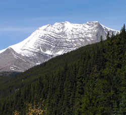
Photo: Looking north to Mount Coleman from the Icefields Parkway
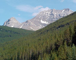
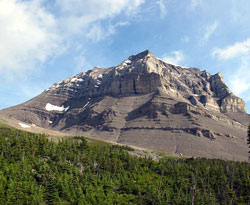
Photo: Looking north-northwest to Mount Coleman from the Icefields Parkway
Looking north to Mount Coleman from near Norman Lake (courtesy Sonny Bou)