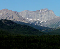
Photo: Mount McLaren (left) and Chinook Peak from the east near Blairmore on Highway #3
Chinook Peak
- 2591 m (8,501ft)
- Naming History
Located in the Crowsnest River Valley between Ptolemy Creek and Star Creek headwaters
Range: Flathead
Province: Alberta
Headwater: Oldman
Major Valley: Crowsnest
Visible from Highway: 3
Named by: Jim Kerr
Named for: Jim Kerr looked directly at the peak from his living room window and during a cold spell he would watch it and when the snow started to blow off the top from the west he knew that a chinook was not far behind.
The mountain was named by Jim Kerr, a lifelong resident of the Crowsnest Pass who lived on Sherman Parrish's original homestead. Jim looked directly at the peak from his living room window and during a cold spell he would watch it and when the snow started to blow off the top from the west he knew that a chinook was not far behind. The name became official in 1962, when it was suggested by Dr. R.A. Price, the head of a Geological Survey of Canada party working in the area. Chinook Peak features a natural arch known as the "Bridge of the Mastodons."
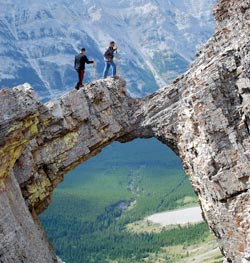
Looking southwest to The Bridge of the Mastedon on Chinook Peak (courtesy Benn Ingram)
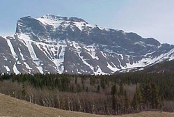
Photo: Chinook Peak from the west on Highway #3