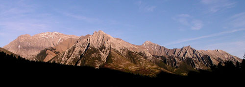
Photo: Looking east to Mount Charles Stewart from Highway #1 (l-r) The nw end of Mount Charles Stewart, Princess Margaret Mtn, the se summit of Mount Charles Stewart, Squaw's Tit, and Mt Lady Macdonal
Mount Charles Stewart
- 2809 m (9,216ft)
- First Ascent
- Naming History
Located in the Bow River Valley north of the headwaters of Cougar Creek
Range: Fairholme
Province: Alberta
Park: Kananaskis/Banff
Headwater: Bow
Major Valley: Bow
Visible from Highway: 1, 742
Ascent Party: R.C. Hind, Mr. And Mrs. H.H. Rans, J.F. Tarrant
Named for: Stewart, Hon. Charles (Charles Stewart was a former premier of Alberta and federal cabinet minister.)
Mount Charles Stewart is a long ridge that parallels the Bow Valley to the northeast of Canmore. Mount Lady Macdonald lies at the southeastern end of the ridge. Princess Margaret Mountain is an outlier of Mount Charles Stewart. It stands at the end of a ridge that extend to the southwest and so are prominent when viewed from the Bow Valley and the Town of Canmore. The boundary of Banff National Park includes Princess Margaret Mountain and passes through the highest point of Mount Charles Stewart. A prominent high point on the main ridge of Mount Charles Stewart lies 1.6 km southeast of the main summit, but is approximatly 150 feet lower than the main, broader summit. Charles Stewart (1868-1946) was born in Ontario but moved to the Killam district of Alberta. He was elected to the provincial legislature in 1909, began serving as a cabinet minister in 1912, and then as the Premier of Alberta from 1917 to 1921. He then became a cabinet minister in the federal government where he served as Minister of the Interior from 1921 until 1930. The mountain is one of a very few in which both the first and last name of the individual is attached to the feature. There was a Mount Stewart already when it was determined, in 1928, that Mr. Stewart should be honoured. The authorities are reluctant to apply the same name to more than one mountain and perhaps appropriate political connections were made use of to "bend the rules" somewhat and allow Charles Stewart to have his mountain.
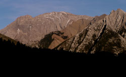
Photo: Looking east to the northwest (highest) summit of Mount Charles Stewart (Mount Princess Margaret at right) from Highway #1