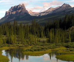
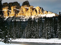
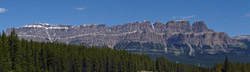
Photo: Looking northwest to (l-r) Castle Mountain, Stuart Knob, and Helena Ridge from the Trans-Canada Highway
Castle Mountain (Alberta)
- 2766 m (9,076ft)
- First Ascent
- Naming History
Located in the Bow River Valley west of Silverton Creek and opposite Vermilion Pass
Province: Alberta
Park: Banff
Headwater: Bow
Major Valley: Bow
Visible from Highway: 1, 93S
Ascent Party: Arthur Coleman
Named by: James Hector
Named for: The mountain was named for its fortress or castle-like appearance.
James Hector was still nineteen kilometres down the Bow Valley from what is now known as Castle Junction when he decided what the name of this mountain should be. He wrote, "Seeming to stand out in the centre of the valley is a very remarkable mountain... which looks exactly like a giant castle." When Sir Sandford Fleming travelled up the valley during the construction of the CPR he seemed to agree with the appropriateness of the name, writing, "Westward we see Castle Mountain to our right. The resemblance to Cyclopean masonary has doubtless suggested the name, for it is marked by huge masses of castellated-looking work, with turreted flanks." One of the most imposing peaks in the Bow Valley, the bold, castellated southwest front of the mountain dominates the view for much of the journey from Banff to Lake Louise, its bulk, prominent position as noted by Hector, and reddish colour combining to make this a favourite of many who pass this way. Two levels of steep cliffs form the "castle" part of Castle Mountain. The ledge between is the Stephen Formation which correlates westward to the rocks that contain the Burgess Shale fossils in Yoho National Park. Despite the appropriateness of Dr. Hector’s name and the fact that it had been used for almost one hundred years, the mountain was renamed Mount Eisenhower in 1946 in honour of American General Dwight D. Eisenhower, the Supreme Commander of the Allied Forces in Europe during the final year of World War II. The decision to rename Castle Mountain was made by Prime Minister Mackenzie-King on the day before the President was to pay a visit to Ottawa. As much as Eisenhower was respected, this arbitrary decision so enraged the Alberta government that it immediately formed its own geographical names board. It took thirty-three years and an Albertan as Prime Minister before Castle Mountain regained its original name in 1979. As a compromise, the prominent tower on the southern end of the mountain was given the name Eisenhower Peak. After naming the mountain, James Hector made a side-trip, climbing through the forest and passed, ". . .round to the north side of the mountain, and found that a deep valley separated it from a lower spur composed of splintery shale of a dull red colour." This was the valley that contains Rockbound Lake, the high ridge to the north being Helena Ridge. After visiting the Selkirks in 1884, Arthur Coleman stopped below Castle Mountain. From there he ascended to camp in "the beautiful Horseshoe Valley behind the Castle" from which he made the first ascent of the mountain. Coleman wrote, "Some of the climbing was quite risky work, since the projecting knobs of rock were oten loose, and gave way under the hand or foot. Above the edge of the cliff, however, going was easy, so that the highest part of the Castle (nine thousand feet) was not hard to reach, and the wonderful view of the valley of Bow River, four thousand feet below, was quite worth seeing. The tower standing in front of the Castle to the south-east looked as unscalable as it was reported to be." Please note that there is another Castle Mountain in British Columbia, Castle Rock in the front ranges west of Benchlands, and Castle Peak southwest of Pincher Creek. MAIN RANGES AND THE SAWBACK RANGE Having had considerable training in geology, Dr. James Hector would undoubtedly have noticed the abrupt change in geology between Castle Mountain and the Sawback Range. Geologists separate the Rocky Mountains of western Canada into four different zones which relate to the style and degree of their structural deformation. In the Foothills area the rock layers have been folded and faulted but not uplifted to a great extent. Farther west the Front Ranges appear, their eastern edge forming a very distinct boundary where older limestones have been exposed. These ranges are composed of a series of thrust faults that underlie panels of rock which overlap like the shingles on a roof. They are almost always tilted down to the west in varying amounts. To the west of the Front Ranges lie the Main Ranges of the Rockies in which the sedimentary layers remain relatively undisturbed although they have been uplifted significantly and moved eastward. Farther west, the layers of the Western Ranges are severely broken, faulted, and folded. The western boundary of the Rockies is the "Rocky Mountain Trench," a major valley filled with thick deposits of sands and gravels and containing major rivers such as the Columbia. Castle Mountain is noteworthy because it is the eastern-most mountain of the Main Ranges in the Bow Valley. The rock is PreCambrian and Cambrian in age and the rock layers are relatively horizontal. The Castle Mountain Fault has thrust the older (400-600 million years) limestone which forms the cliffs and underlying older rocks over younger (200 million years) rock which has eroded and forms the tree-covered, gently sloped base of the peak. This fault defines the boundary between the Main Ranges and the Front Ranges and can be traced throughout Banff and into Jasper National Park where it passes between The Palisade and Pyramid Mountain, just east of Jasper Townsite. Castle Mountain is, appropriately, a "castellate" type of mountain in which the flat-lying layers feature near vertical cliffs alternating with flat or gently sloped terraces which have been sculptured by glacial and other forms of erosion. The layers of rock involved vary in their resistance to erosion, the harder rock such as limestone being more resistant and softer rock such as shale eroding more easily. Castle Mountain demonstrates these principles with its two major cliffs of limestone being separated by a ledge which corresponds to a layer of shale. While Castle Mountain is the easternmost of the Main Ranges, the Sawback Range, which was appropriately named by James Hector, is the westernmost of the Front Ranges. In this range the strata has been tilted to near vertical. "Sawtooth" type mountains have been formed as the steeply dipping, thin layers of sedimentary strata are eroded by cross gullies to form a series of inverted "V's' which resemble the teeth of a saw.
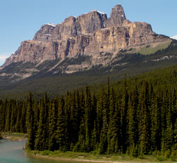
Photo: Looking north-northwest to Castle Mountain (Eisenhower Peak at right) from the Bow Valley
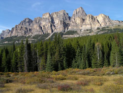
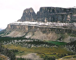
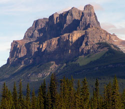
Looking north to Castle Mountain from the Bow Valley Parkway, just northwest of Castle Junction
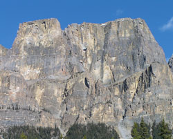
Looking north-northeast to the highest point on Castle Mountain from the Bow Valley Parkway
Looking east-northeast to Castle Mountain from Mount Bell (courtesy Sonny Bou)
Looking north to Castle Mountain from the Bow Valley (courtesy Calvin Damen)
Looking south to Castle Mountain (Eisenhower Peak at left) (courtesy Calvin Damen)
Looking east-southeast to Castle Mountain from Panorama Ridge (courtesy Sonny Bou)
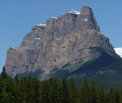
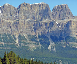
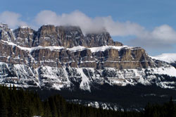
Looking north-northwest to Castle Mountain from the Trans-Canada Highway
Looking east-northeast to Castle Mountain from Highway #93 near Vermilion Pass
Looking east-northeast to Castle Mountain from Highway #93 near Vermilion Pass
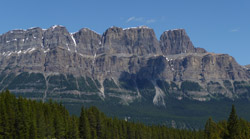
Looking east to the northeast end of Castle Mountain from the Bow Valley Parkway
Looking northeast to the highest point of Castle Mountain from Highway #93 near Vermilion Pass
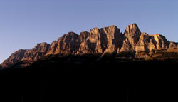
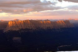
Looking northeast to vening light on Castle Mountain from the Trans-Canada Highway
Looking north-northwest to Castle Mountain from the Trans-Canada Highway
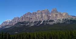
Looking northeast to Castle Mountain from the Trans-Canada Highway
Looking northeast to Castle Mountain from near Vermilion Pass on Highway #93(S)
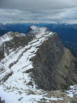
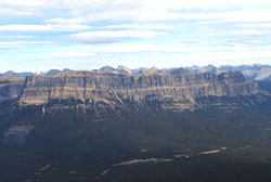
Looking southeast along the length of Castle Mountain (courtesy Sonny Bou)
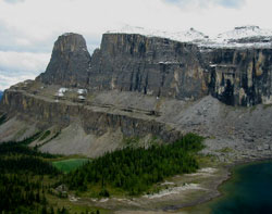
Looking south across Tower Lake and Rockbound Lake to Castle Mountain (courtesy Sonny Bou)
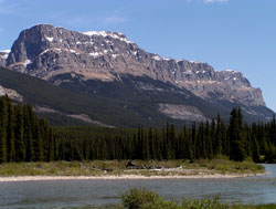
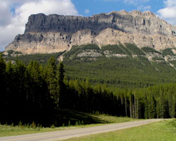
Looking east to Castle Mountain from the the Trans-Canada Highway