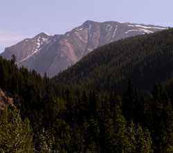
Photo: Looking northeast up the Grant Brook Valley to Caledonia Mountain from Hwy. #16
Caledonia Mountain
- 2856 m (9,371ft)
- Naming History
Located on the continental divide between Grant River Valley and Miette River Valley
Province: Alberta/BC
Park: Jasper/Mount Robson
Headwater: Athabasca/Fraser
Visible from Highway: 16
Named for: Simon Fraser named the area between the Rocky Mountains and the Coast Range (north of 51 degrees 30 minutes) New Caledonia because the country reminded him of his mother's descriptions of her native Scotland.
Simon Fraser named the area between the Rocky Mountains and the Coast Range (north of 51 degrees 30 minutes) New Caledonia because the country reminded him of his mother's descriptions of her native Scotland. The name was retained when fur traders of the Hudson's Bay Company began to regularly traverse the Yellowhead Pass while travelling to and from this portion of the HBC's empire. The mountain likely takes its name from Caledonian Valley, which was an early name for the Miette Valley which the mountain rises above. When viewed from the east during mid-summer, the mountain features a number of distinctive, long, thin lines of snow rising steeply from left to right on its upper cliffs. In contrast the lower mountain directly in front of Caledonia has an almost vertical, long, thin line of snow, from its highest point to the valley below.
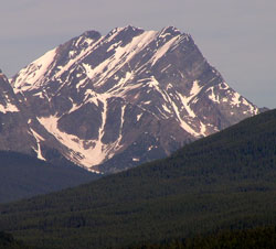
Photo: Looking west to Caledonia Mountain from Hwy. #16 near the Clairvaux Creek Bridge