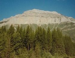
Photo: Mount Broadwood from the south on the Wigwam River (courtesy Rob Cowie)
Mount Broadwood
- 2423 m (7,950ft)
- Naming History
49.2969N -114.990W
Located in the Lower Elk River Valley north of Wigwam River and west of Lodgepole Creek
Province: BC
Headwater: Kootenay
Visible from Highway: 3
Located in the Lower Elk River Valley north of Wigwam River and west of Lodgepole Creek
Province: BC
Headwater: Kootenay
Visible from Highway: 3
Year Named: 1902
Named for: Broadwood, Lewis (An Englishman, Lewis Broadwood hunted and fished near the mountain around the year 1898.)
Named for: Broadwood, Lewis (An Englishman, Lewis Broadwood hunted and fished near the mountain around the year 1898.)
Thomas Blakiston is said to have referred to this mountain as North Bluff during his travels through the area in 1858. [Haig] This peak is identified as North Bluff on George Dawson's 1886 map. The mountain across the Wigwam River Valley to the south is shown as South Bluff. It is currently un-named. To the east of South Bluff on Dawson's map, the peak shown as 7708' on NTS 82G is named Sharp Peak.